Erstein night lights from space
Night Light of Erstein (Grand Est) from space (France) Src. Average luminocity for 10x10km area is 24.0781% and for 50x50km: 20.9357%.
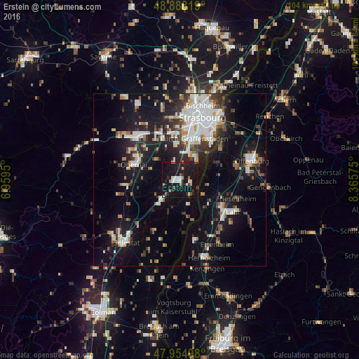
Analysis of Erstein night lights 2016
Square area 10x10 km:
 2.84%
2.84%90-99
4.69%80-89
1.99%70-79
2.7%60-69
0.99%50-59
1.28%40-49
1.56%30-39
2.27%20-29
5.26%10-19
52.27%0-9
24.15%Square area 50x50 km:
4.68%90-99
4.22%80-89
1.41%70-79
1.39%60-69
2.01%50-59
1.94%40-49
2.14%30-39
3.32%20-29
5.25%10-19
17.24%0-9
56.41%Clear (daylight) street map image can be seen on geolist.org.
Map coordinates:
48° 53' 17.5" North, 6° 57' 34.2" East
48° 25' 25.4" North, 7° 39' 45.4" East
47° 57' 17.9" North, 8° 21' 56.7" East
Some cities around Erstein sort by population:
• Illkirch-Graffenstaden
12.3 km =7.6 mi,  18°
18°
• Lingolsheim
14.9 km =9.3 mi,  5°
5°
• Obernai
14.1 km =8.8 mi,  288°
288°
• Ostwald
13.8 km =8.6 mi, 14°
• Geispolsheim
10.3 km =6.4 mi,  354°
354°
• Schwanau, DE
9.7 km =6 mi,  130°
130°
• Barr
15.9 km =9.9 mi,  263°
263°
• Benfeld
7.8 km =4.8 mi,  220°
220°
3019865 (p: 9,647)
Sources (retrieved 2019-11-25):
» Earth at Night: Flat Maps 2012, 2016