Schongau night lights from space
Night Light of Schongau (Bavaria) from space (Germany) Src. Average luminocity for 10x10km area is 8.4286% and for 50x50km: 1.9804%.
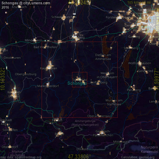
Analysis of Schongau night lights 2016
Square area 10x10 km:
 0.45%
0.45%90-99
0.15%80-89
0.74%70-79
0.45%60-69
4.76%50-59
2.38%40-49
1.19%30-39
0.6%20-29
0.6%10-19
0.45%0-9
88.24%Square area 50x50 km:
0.11%90-99
0.18%80-89
0.19%70-79
0.29%60-69
0.42%50-59
0.3%40-49
0.31%30-39
0.4%20-29
0.42%10-19
0.7%0-9
96.68%Clear (daylight) street map image can be seen on geolist.org.
Map coordinates:
48° 16' 56.8" North, 10° 11' 36.7" East
47° 48' 44.6" North, 10° 53' 47.9" East
47° 20' 17" North, 11° 35' 59.2" East
Some cities around Schongau sort by population:
• Kaufbeuren
21.9 km =13.6 mi,  290°
290°
• Landsberg am Lech
26.2 km =16.3 mi,  357°
357°
• Weilheim
19.5 km =12.1 mi,  80°
80°
• Marktoberdorf
21.2 km =13.2 mi,  260°
260°
• Peißenberg
13 km =8.1 mi,  93°
93°
• Peiting
3.1 km =1.9 mi,  127°
127°
• Dießen am Ammersee
21.8 km =13.5 mi,  44°
44°
• Oberammergau
27 km =16.8 mi,  151°
151°
2836616 (p: 12,442)
Sources (retrieved 2019-11-25):
» Earth at Night: Flat Maps 2012, 2016