Peißenberg night lights from space
Night Light of Peißenberg (Bavaria) from space (Germany) Src. Average luminocity for 10x10km area is 3.7232% and for 50x50km: 1.1813%.
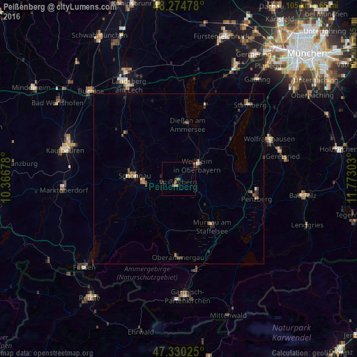
Analysis of Peißenberg night lights 2016
Square area 10x10 km:
 0%
0%90-99
0%80-89
0%70-79
0%60-69
2.08%50-59
1.49%40-49
1.19%30-39
0.74%20-29
0.45%10-19
0%0-9
94.05%Square area 50x50 km:
0.03%90-99
0.07%80-89
0.06%70-79
0.16%60-69
0.33%50-59
0.3%40-49
0.3%30-39
0.21%20-29
0.31%10-19
0.16%0-9
98.07%Clear (daylight) street map image can be seen on geolist.org.
Map coordinates:
48° 16' 29.2" North, 10° 22' 0.4" East
47° 48' 16.8" North, 11° 4' 11.6" East
47° 19' 48.9" North, 11° 46' 22.9" East
Some cities around Peißenberg sort by population:
• Weilheim
7.5 km =4.7 mi,  57°
57°
• Schongau
13 km =8.1 mi,  273°
273°
• Peiting
10.5 km =6.5 mi,  264°
264°
• Murnau am Staffelsee
16.9 km =10.5 mi,  144°
144°
• Dießen am Ammersee
16.4 km =10.2 mi,  8°
8°
• Herrsching am Ammersee
23 km =14.3 mi,  20°
20°
• Tutzing
19.5 km =12.1 mi,  53°
53°
• Oberammergau
23 km =14.3 mi,  180°
180°
2855029 (p: 12,695)
Sources (retrieved 2019-11-25):
» Earth at Night: Flat Maps 2012, 2016