Schöffengrund night lights from space
Night Light of Schöffengrund (Hesse) from space (Germany) Src. Average luminocity for 10x10km area is 1.2675% and for 50x50km: 4.373%.
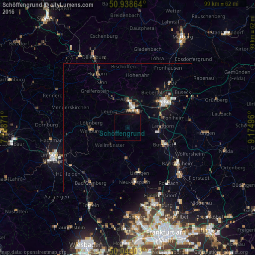
Analysis of Schöffengrund night lights 2016
Square area 10x10 km:
 0%
0%90-99
0%80-89
0%70-79
0%60-69
0%50-59
0%40-49
0%30-39
0.14%20-29
0.14%10-19
1.12%0-9
98.6%Square area 50x50 km:
0.52%90-99
0.59%80-89
0.4%70-79
0.46%60-69
0.55%50-59
0.43%40-49
0.71%30-39
0.62%20-29
0.57%10-19
3.09%0-9
92.05%Clear (daylight) street map image can be seen on geolist.org.
Map coordinates:
50° 56' 19.1" North, 7° 46' 7.4" East
50° 29' 36.4" North, 8° 28' 18.6" East
50° 2' 38.5" North, 9° 10' 29.9" East
Some cities around Schöffengrund sort by population:
• Wetzlar
7.9 km =4.9 mi,  17°
17°
• Aßlar
10.9 km =6.8 mi,  356°
356°
• Solms
6.6 km =4.1 mi,  316°
316°
• Braunfels
6.3 km =3.9 mi,  292°
292°
• Weilmünster
9.6 km =6 mi,  224°
224°
• Selters
13.2 km =8.2 mi,  281°
281°
• Leun
10.3 km =6.4 mi,  308°
308°
• Grävenwiesbach
11.5 km =7.1 mi,  185°
185°
3208118 (p: 6,316)
Sources (retrieved 2019-11-25):
» Earth at Night: Flat Maps 2012, 2016