Grävenwiesbach night lights from space
Night Light of Grävenwiesbach (Hesse) from space (Germany) Src. Average luminocity for 10x10km area is 0.9426% and for 50x50km: 7.7979%.
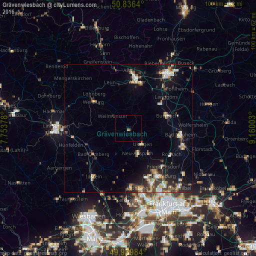
Analysis of Grävenwiesbach night lights 2016
Square area 10x10 km:
 0%
0%90-99
0%80-89
0%70-79
0%60-69
1.12%50-59
0%40-49
0%30-39
0%20-29
0%10-19
0%0-9
98.88%Square area 50x50 km:
0.95%90-99
1.16%80-89
0.81%70-79
0.9%60-69
0.93%50-59
0.79%40-49
1.19%30-39
1.46%20-29
2.04%10-19
5.28%0-9
84.49%Clear (daylight) street map image can be seen on geolist.org.
Map coordinates:
50° 50' 11" North, 7° 45' 13.6" East
50° 23' 24.9" North, 8° 27' 24.8" East
49° 56' 23.4" North, 9° 9' 36.1" East
Some cities around Grävenwiesbach sort by population:
• Butzbach
15.9 km =9.9 mi,  72°
72°
• Neu-Anspach
8.7 km =5.4 mi,  159°
159°
• Usingen
8.3 km =5.2 mi,  136°
136°
• Braunfels
14.7 km =9.1 mi,  340°
340°
• Weilmünster
7.3 km =4.5 mi,  308°
308°
• Wehrheim
12.7 km =7.9 mi, 142°
• Schmitten
13.7 km =8.5 mi,  182°
182°
• Schöffengrund
11.5 km =7.1 mi,  5°
5°
2917868 (p: 5,245)
Sources (retrieved 2019-11-25):
» Earth at Night: Flat Maps 2012, 2016