Leun night lights from space
Night Light of Leun (Hesse) from space (Germany) Src. Average luminocity for 10x10km area is 0.4906% and for 50x50km: 4.3109%.
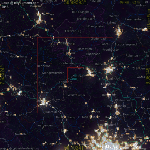
Analysis of Leun night lights 2016
Square area 10x10 km:
 0%
0%90-99
0%80-89
0%70-79
0%60-69
0%50-59
0.13%40-49
0.4%30-39
0%20-29
0.53%10-19
0%0-9
98.93%Square area 50x50 km:
0.59%90-99
0.69%80-89
0.34%70-79
0.45%60-69
0.58%50-59
0.52%40-49
0.66%30-39
0.51%20-29
0.5%10-19
3.55%0-9
91.62%Clear (daylight) street map image can be seen on geolist.org.
Map coordinates:
50° 59' 45.3" North, 7° 39' 18.9" East
50° 33' 4.6" North, 8° 21' 30.1" East
50° 6' 8.7" North, 9° 3' 41.4" East
Some cities around Leun sort by population:
• Weilburg
10.1 km =6.3 mi,  222°
222°
• Aßlar
8.6 km =5.3 mi,  58°
58°
• Solms
3.8 km =2.4 mi,  116°
116°
• Braunfels
4.5 km =2.8 mi,  151°
151°
• Ehringshausen
5.7 km =3.5 mi,  18°
18°
• Selters
6.2 km =3.9 mi,  231°
231°
• Greifenstein
8.4 km =5.2 mi,  330°
330°
• Schöffengrund
10.3 km =6.4 mi,  128°
128°
2878351 (p: 6,116)
Sources (retrieved 2019-11-25):
» Earth at Night: Flat Maps 2012, 2016