Sarstedt night lights from space
Night Light of Sarstedt (Lower Saxony) from space (Germany) Src. Average luminocity for 10x10km area is 9.209% and for 50x50km: 12.4619%.
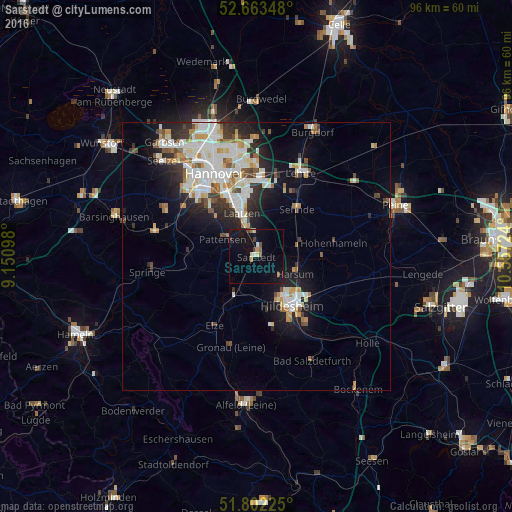
Analysis of Sarstedt night lights 2016
Square area 10x10 km:
 0%
0%90-99
1.32%80-89
1.19%70-79
0.93%60-69
0.79%50-59
1.59%40-49
1.06%30-39
0.4%20-29
0.4%10-19
11.77%0-9
80.56%Square area 50x50 km:
2.85%90-99
3.1%80-89
1.17%70-79
1.3%60-69
1.18%50-59
1.2%40-49
1.05%30-39
1.28%20-29
2.75%10-19
5.97%0-9
78.15%Clear (daylight) street map image can be seen on geolist.org.
Map coordinates:
52° 39' 48.5" North, 9° 9' 3.5" East
52° 14' 5.8" North, 9° 51' 14.8" East
51° 48' 8.1" North, 10° 33' 26.1" East
Some cities around Sarstedt sort by population:
• Hildesheim
11.5 km =7.1 mi,  144°
144°
• Laatzen
9.7 km =6 mi,  336°
336°
• Sehnde
11.7 km =7.3 mi,  41°
41°
• Pattensen
6.9 km =4.3 mi,  298°
298°
• Nordstemmen
9.4 km =5.8 mi,  210°
210°
• Harsum
8 km =5 mi,  109°
109°
• Giesen
5.2 km =3.2 mi, 144°
• Algermissen
8.1 km =5 mi,  75°
75°
2841386 (p: 18,718)
Sources (retrieved 2019-11-25):
» Earth at Night: Flat Maps 2012, 2016