Nordstemmen night lights from space
Night Light of Nordstemmen (Lower Saxony) from space (Germany) Src. Average luminocity for 10x10km area is 1.1336% and for 50x50km: 8.0306%.
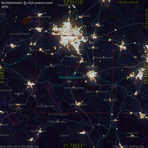
Analysis of Nordstemmen night lights 2016
Square area 10x10 km:
 0.26%
0.26%90-99
0.26%80-89
0%70-79
0%60-69
0%50-59
0%40-49
0.26%30-39
0.26%20-29
0.53%10-19
0%0-9
98.41%Square area 50x50 km:
1.52%90-99
1.9%80-89
0.74%70-79
0.8%60-69
0.8%50-59
0.81%40-49
0.85%30-39
0.85%20-29
1.81%10-19
4.8%0-9
85.12%Clear (daylight) street map image can be seen on geolist.org.
Map coordinates:
52° 35' 28.3" North, 9° 4' 49.3" East
52° 9' 43.1" North, 9° 47' 0.6" East
51° 43' 42.8" North, 10° 29' 11.9" East
Some cities around Nordstemmen sort by population:
• Hildesheim
11.5 km =7.1 mi,  96°
96°
• Sarstedt
9.4 km =5.8 mi,  30°
30°
• Pattensen
11.5 km =7.1 mi,  353°
353°
• Harsum
13.5 km =8.4 mi,  66°
66°
• Giesen
8.8 km =5.5 mi,  63°
63°
• Elze
5.4 km =3.4 mi,  216°
216°
• Diekholzen
11.8 km =7.3 mi,  128°
128°
• Gronau
8.6 km =5.3 mi,  183°
183°
2861866 (p: 13,148)
Sources (retrieved 2019-11-25):
» Earth at Night: Flat Maps 2012, 2016