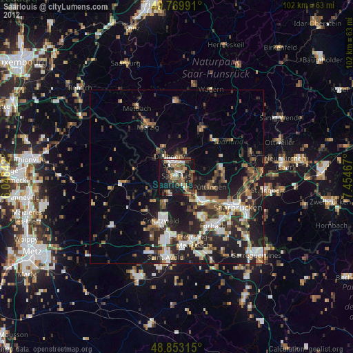
Saarlouis night lights from space
Night Light of Saarlouis (Saarland) from space (Germany) Src. Average luminocity for 10x10km area is 37.0936% and for 50x50km: 16.8073%.
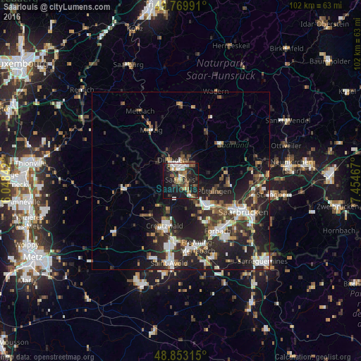
Analysis of Saarlouis night lights 2016
Square area 10x10 km:
 6.42%
6.42%90-99
5.35%80-89
2.94%70-79
3.34%60-69
5.35%50-59
6.28%40-49
7.49%30-39
5.35%20-29
10.16%10-19
35.83%0-9
11.5%Square area 50x50 km:
2.75%90-99
2.89%80-89
1.05%70-79
1.48%60-69
2.07%50-59
2.27%40-49
2.51%30-39
3.21%20-29
7.8%10-19
12.87%0-9
61.1%Clear (daylight) street map image can be seen on geolist.org.
Map coordinates:
49° 46' 11.7" North, 6° 2' 54.3" East
49° 18' 49.2" North, 6° 45' 5.5" East
48° 51' 11.3" North, 7° 27' 16.8" East
Some cities around Saarlouis sort by population:
• Dillingen
5 km =3.1 mi,  339°
339°
• Schwalbach
5 km =3.1 mi,  107°
107°
• Wadgassen
5.7 km =3.5 mi,  156°
156°
• Saarwellingen
5.9 km =3.7 mi,  40°
40°
• Wallerfangen
3.3 km =2.1 mi,  297°
297°
• Nalbach
8.1 km =5 mi,  16°
16°
• Bous
5.4 km =3.4 mi,  138°
138°
• Ensdorf
2.8 km =1.7 mi,  123°
123°
2842632 (p: 38,333)
Sources (retrieved 2019-11-25):
» Earth at Night: Flat Maps 2012, 2016