Bous night lights from space
Night Light of Bous (Saarland) from space (Germany) Src. Average luminocity for 10x10km area is 33.266% and for 50x50km: 19.4065%.
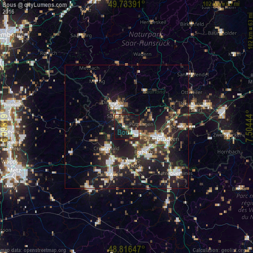
Analysis of Bous night lights 2016
Square area 10x10 km:
 5.08%
5.08%90-99
4.55%80-89
2.54%70-79
2.94%60-69
4.28%50-59
4.81%40-49
5.48%30-39
4.95%20-29
12.03%10-19
43.98%0-9
9.36%Square area 50x50 km:
3.03%90-99
3.18%80-89
1.29%70-79
1.73%60-69
2.31%50-59
2.65%40-49
2.83%30-39
3.51%20-29
8.61%10-19
17.3%0-9
53.55%Clear (daylight) street map image can be seen on geolist.org.
Map coordinates:
49° 44' 2.1" North, 6° 5' 53.5" East
49° 16' 38.4" North, 6° 48' 4.7" East
48° 48' 59.3" North, 7° 30' 16" East
Some cities around Bous sort by population:
• Völklingen
5.1 km =3.2 mi,  124°
124°
• Saarlouis
5.4 km =3.4 mi,  318°
318°
• Püttlingen
6.3 km =3.9 mi,  81°
81°
• Schwalbach
2.8 km =1.7 mi,  23°
23°
• Wadgassen
1.8 km =1.1 mi,  227°
227°
• Petite-Rosselle, FR
8.3 km =5.2 mi,  151°
151°
• Ensdorf
2.8 km =1.7 mi,  332°
332°
• Ludweiler-Warndt
6.3 km =3.9 mi,  173°
173°
2945730 (p: 7,605)
Sources (retrieved 2019-11-25):
» Earth at Night: Flat Maps 2012, 2016