Rödental night lights from space
Night Light of Rödental (Bavaria) from space (Germany) Src. Average luminocity for 10x10km area is 12.0267% and for 50x50km: 2.2595%.
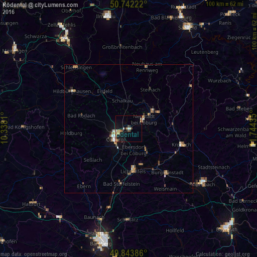
Analysis of Rödental night lights 2016
Square area 10x10 km:
 0.53%
0.53%90-99
1.87%80-89
1.74%70-79
1.87%60-69
2.01%50-59
1.34%40-49
1.74%30-39
0.13%20-29
1.6%10-19
10.43%0-9
76.74%Square area 50x50 km:
0.19%90-99
0.31%80-89
0.17%70-79
0.35%60-69
0.48%50-59
0.37%40-49
0.42%30-39
0.13%20-29
0.23%10-19
1.06%0-9
96.29%Clear (daylight) street map image can be seen on geolist.org.
Map coordinates:
50° 44' 32" North, 10° 20' 17.2" East
50° 17' 42.6" North, 11° 2' 28.4" East
49° 50' 37.9" North, 11° 44' 39.7" East
Some cities around Rödental sort by population:
• Coburg
6.8 km =4.2 mi,  234°
234°
• Sonneberg
11.8 km =7.3 mi,  53°
53°
• Lichtenfels
16.7 km =10.4 mi,  175°
175°
• Neustadt bei Coburg
6.8 km =4.2 mi,  55°
55°
• Michelau
15.6 km =9.7 mi,  161°
161°
• Ebersdorf
8.8 km =5.5 mi, 64°
• Sonnefeld
10.9 km =6.8 mi,  143°
143°
• Weitramsdorf
12.3 km =7.6 mi,  249°
249°
3207410 (p: 13,712)
Sources (retrieved 2019-11-25):
» Earth at Night: Flat Maps 2012, 2016