Riehl night lights from space
Night Light of Riehl (North Rhine-Westphalia) from space (Germany) Src. Average luminocity for 10x10km area is 86.6485% and for 50x50km: 35.215%.
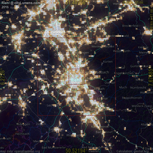
Analysis of Riehl night lights 2016
Square area 10x10 km:
 31.93%
90-99
27.45%80-89
9.38%70-79
10.22%60-69
13.03%50-59
5.46%40-49
1.82%30-39
0.7%20-29
0%10-19
0%0-9
0%Square area 50x50 km:
6.57%90-99
6.99%80-89
3.23%70-79
3.66%60-69
4.86%50-59
5.22%40-49
5.25%30-39
7.69%20-29
9.41%10-19
16.2%0-9
30.92%Clear (daylight) street map image can be seen on geolist.org.
Map coordinates:
51° 24' 27.2" North, 6° 16' 21.4" East
50° 58' 0.7" North, 6° 58' 32.6" East
50° 31' 19" North, 7° 40' 43.9" East
Some cities around Riehl sort by population:
• Nippes
1.6 km =1 mi,  264°
264°
• Mülheim
2 km =1.2 mi,  91°
91°
• Neustadt/Nord
2.8 km =1.7 mi,  224°
224°
• Neuehrenfeld
3 km =1.9 mi,  249°
249°
• Altstadt Nord
3.4 km =2.1 mi,  202°
202°
• Bilderstoeckchen
3.2 km =2 mi,  275°
275°
• Buchheim
3.6 km =2.2 mi,  118°
118°
• Buchforst
2.8 km =1.7 mi,  130°
130°
2847013 (p: 11,188)
Sources (retrieved 2019-11-25):
» Earth at Night: Flat Maps 2012, 2016