Kelsterbach night lights from space
Night Light of Kelsterbach (Hesse) from space (Germany) Src. Average luminocity for 10x10km area is 74.2633% and for 50x50km: 32.3991%.
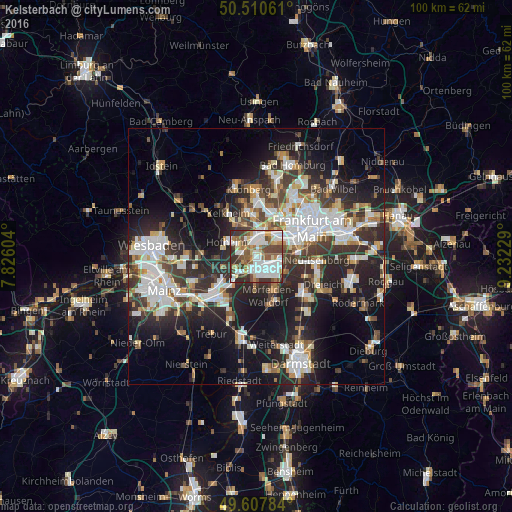
Analysis of Kelsterbach night lights 2016
Square area 10x10 km:
 23.95%
90-99
21.71%80-89
6.16%70-79
5.46%60-69
7.14%50-59
9.66%40-49
12.75%30-39
8.12%20-29
5.04%10-19
0%0-9
0%Square area 50x50 km:
7.42%90-99
7.05%80-89
2.69%70-79
2.91%60-69
3.36%50-59
2.85%40-49
4.25%30-39
5.83%20-29
10.99%10-19
16.57%0-9
36.06%Clear (daylight) street map image can be seen on geolist.org.
Map coordinates:
50° 30' 38.2" North, 7° 49' 33.7" East
50° 3' 40.9" North, 8° 31' 45" East
49° 36' 28.2" North, 9° 13' 56.2" East
Some cities around Kelsterbach sort by population:
• Gallus
8.4 km =5.2 mi,  58°
58°
• Hofheim am Taunus
6.5 km =4 mi,  299°
299°
• Hattersheim
4.3 km =2.7 mi, 296°
• Niederrad
7.5 km =4.7 mi,  71°
71°
• Raunheim
7.7 km =4.8 mi,  225°
225°
• Kriftel
4.9 km =3 mi, 300°
• Liederbach
7.2 km =4.5 mi,  339°
339°
• Sulzbach
8.1 km =5 mi,  359°
359°
2891742 (p: 13,836)
Sources (retrieved 2019-11-25):
» Earth at Night: Flat Maps 2012, 2016