Plön night lights from space
Night Light of Plön (Schleswig-Holstein) from space (Germany) Src. Average luminocity for 10x10km area is 1.9104% and for 50x50km: 4.2999%.
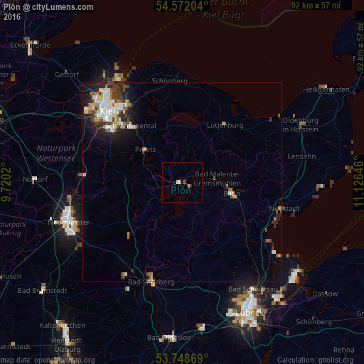
Analysis of Plön night lights 2016
Square area 10x10 km:
 0.25%
0.25%90-99
0.76%80-89
0.38%70-79
0.13%60-69
0%50-59
0%40-49
0.51%30-39
0%20-29
0.51%10-19
0%0-9
97.47%Square area 50x50 km:
0.74%90-99
0.95%80-89
0.39%70-79
0.42%60-69
0.5%50-59
0.49%40-49
0.56%30-39
0.7%20-29
1.15%10-19
2.1%0-9
92%Clear (daylight) street map image can be seen on geolist.org.
Map coordinates:
54° 34' 19.3" North, 9° 43' 12.7" East
54° 9' 44.7" North, 10° 25' 24" East
53° 44' 55.3" North, 11° 7' 35.3" East
Some cities around Plön sort by population:
• Eutin
12.2 km =7.6 mi,  101°
101°
• Preetz
12.5 km =7.8 mi,  310°
310°
• Malente
8.9 km =5.5 mi,  82°
82°
• Ahrensbök
19.7 km =12.2 mi,  150°
150°
• Raisdorf
17.4 km =10.8 mi,  319°
319°
• Lütjenburg
18 km =11.2 mi,  36°
36°
• Süsel
20.3 km =12.6 mi,  116°
116°
• Trappenkamp
19.2 km =11.9 mi,  224°
224°
2853162 (p: 13,068)
Sources (retrieved 2019-11-25):
» Earth at Night: Flat Maps 2012, 2016