Neuenstein night lights from space
Night Light of Neuenstein (Baden-Württemberg) from space (Germany) Src. Average luminocity for 10x10km area is 4.5294% and for 50x50km: 2.9699%.
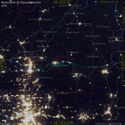
Analysis of Neuenstein night lights 2016
Square area 10x10 km:
 0.7%
0.7%90-99
0.7%80-89
0.98%70-79
0.14%60-69
0%50-59
0.28%40-49
0.7%30-39
0.7%20-29
0.28%10-19
1.4%0-9
94.12%Square area 50x50 km:
0.21%90-99
0.3%80-89
0.27%70-79
0.3%60-69
0.29%50-59
0.51%40-49
0.66%30-39
0.6%20-29
0.58%10-19
2.09%0-9
94.18%Clear (daylight) street map image can be seen on geolist.org.
Map coordinates:
49° 39' 43.8" North, 8° 52' 36.8" East
49° 12' 17.6" North, 9° 34' 48" East
48° 44' 36.1" North, 10° 16' 59.3" East
Some cities around Neuenstein sort by population:
• Öhringen
5.3 km =3.3 mi,  262°
262°
• Künzelsau
11.4 km =7.1 mi,  41°
41°
• Bretzfeld
10.7 km =6.6 mi,  254°
254°
• Pfedelbach
6.2 km =3.9 mi,  241°
241°
• Ingelfingen
11.9 km =7.4 mi,  26°
26°
• Kupferzell
8.4 km =5.2 mi,  72°
72°
• Mainhardt
14.4 km =8.9 mi,  186°
186°
• Forchtenberg
9.4 km =5.8 mi,  351°
351°
2865557 (p: 6,240)
Sources (retrieved 2019-11-25):
» Earth at Night: Flat Maps 2012, 2016