Ottobeuren night lights from space
Night Light of Ottobeuren (Bavaria) from space (Germany) Src. Average luminocity for 10x10km area is 0.544% and for 50x50km: 2.7938%.
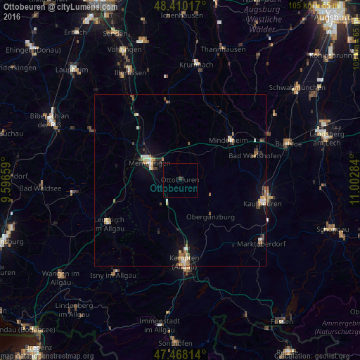
Analysis of Ottobeuren night lights 2016
Square area 10x10 km:
 0%
0%90-99
0%80-89
0%70-79
0%60-69
0%50-59
0%40-49
0.43%30-39
0.14%20-29
0.57%10-19
0%0-9
98.86%Square area 50x50 km:
0.31%90-99
0.39%80-89
0.37%70-79
0.44%60-69
0.28%50-59
0.34%40-49
0.37%30-39
0.39%20-29
0.45%10-19
1.52%0-9
95.14%Clear (daylight) street map image can be seen on geolist.org.
Map coordinates:
48° 24' 36.6" North, 9° 35' 47.7" East
47° 56' 28.7" North, 10° 17' 59" East
47° 28' 5.3" North, 11° 0' 10.2" East
Some cities around Ottobeuren sort by population:
• Kempten (Allgäu)
23.9 km =14.9 mi,  177°
177°
• Memmingen
9.7 km =6 mi,  298°
298°
• Mindelheim
18.4 km =11.4 mi,  50°
50°
• Bad Wörishofen
23.3 km =14.5 mi,  71°
71°
• Altusried
16.5 km =10.3 mi,  202°
202°
• Dietmannsried
14.9 km =9.3 mi, 182°
• Obergünzburg
13.8 km =8.6 mi,  140°
140°
• Babenhausen
22.9 km =14.2 mi,  351°
351°
2855937 (p: 8,095)
Sources (retrieved 2019-11-25):
» Earth at Night: Flat Maps 2012, 2016