Mindelheim night lights from space
Night Light of Mindelheim (Bavaria) from space (Germany) Src. Average luminocity for 10x10km area is 3.983% and for 50x50km: 2.8612%.
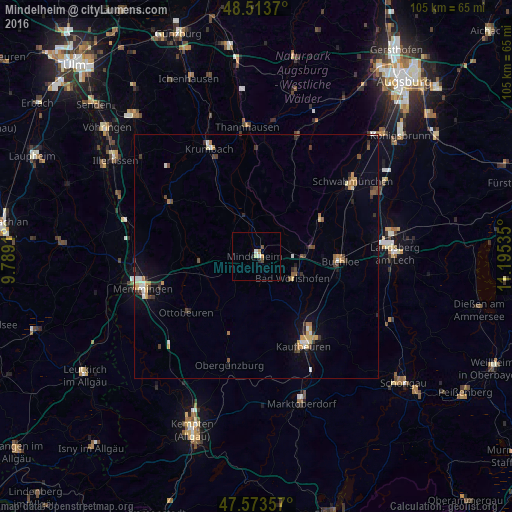
Analysis of Mindelheim night lights 2016
Square area 10x10 km:
 0.43%
0.43%90-99
0.71%80-89
0.57%70-79
1.14%60-69
0%50-59
0.57%40-49
0.57%30-39
0%20-29
0.57%10-19
0.57%0-9
94.89%Square area 50x50 km:
0.21%90-99
0.39%80-89
0.3%70-79
0.47%60-69
0.38%50-59
0.27%40-49
0.46%30-39
0.56%20-29
0.45%10-19
1.07%0-9
95.43%Clear (daylight) street map image can be seen on geolist.org.
Map coordinates:
48° 30' 49.3" North, 9° 47' 20.8" East
48° 2' 44.8" North, 10° 29' 32" East
47° 34' 24.9" North, 11° 11' 43.3" East
Some cities around Mindelheim sort by population:
• Kaufbeuren
20.6 km =12.8 mi,  152°
152°
• Bad Wörishofen
8.9 km =5.5 mi,  119°
119°
• Krumbach
23.8 km =14.8 mi,  336°
336°
• Buchloe
17.4 km =10.8 mi,  93°
93°
• Ottobeuren
18.4 km =11.4 mi,  230°
230°
• Türkheim
11.3 km =7 mi,  79°
79°
• Obergünzburg
22.9 km =14.2 mi,  193°
193°
• Babenhausen
20.9 km =13 mi,  301°
301°
2871045 (p: 14,122)
Sources (retrieved 2019-11-25):
» Earth at Night: Flat Maps 2012, 2016