Neustadt-Glewe night lights from space
Night Light of Neustadt-Glewe (Mecklenburg-Vorpommern) from space (Germany) Src. Average luminocity for 10x10km area is 0.9484% and for 50x50km: 0.9915%.
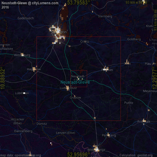
Analysis of Neustadt-Glewe night lights 2016
Square area 10x10 km:
 0%
0%90-99
0%80-89
0%70-79
0%60-69
0.53%50-59
0.53%40-49
0.53%30-39
0%20-29
0%10-19
0%0-9
98.41%Square area 50x50 km:
0.09%90-99
0.18%80-89
0.09%70-79
0.11%60-69
0.14%50-59
0.2%40-49
0.16%30-39
0.06%20-29
0.09%10-19
0.73%0-9
98.14%Clear (daylight) street map image can be seen on geolist.org.
Map coordinates:
53° 47' 45" North, 10° 53' 22.3" East
53° 22' 42.5" North, 11° 35' 33.5" East
52° 57' 25.1" North, 12° 17' 44.8" East
Some cities around Neustadt-Glewe sort by population:
• Schwerin
30.3 km =18.8 mi,  336°
336°
• Parchim
17.8 km =11.1 mi,  72°
72°
• Hagenow
27.2 km =16.9 mi,  282°
282°
• Ludwigslust
8.4 km =5.2 mi,  229°
229°
• Paulsstadt
30.9 km =19.2 mi, 336°
• Karstädt
26 km =16.2 mi,  157°
157°
• Lübz
30.4 km =18.9 mi, 72°
• Grabow
11.1 km =6.9 mi,  189°
189°
2864036 (p: 6,952)
Sources (retrieved 2019-11-25):
» Earth at Night: Flat Maps 2012, 2016