Ludwigslust night lights from space
Night Light of Ludwigslust (Mecklenburg-Vorpommern) from space (Germany) Src. Average luminocity for 10x10km area is 3.0871% and for 50x50km: 0.544%.
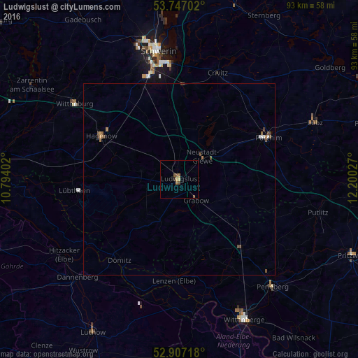
Analysis of Ludwigslust night lights 2016
Square area 10x10 km:
 0%
0%90-99
0%80-89
0.51%70-79
0.88%60-69
0.63%50-59
1.64%40-49
0.38%30-39
0%20-29
0.51%10-19
0%0-9
95.45%Square area 50x50 km:
0.04%90-99
0.05%80-89
0.02%70-79
0.09%60-69
0.11%50-59
0.21%40-49
0.16%30-39
0.03%20-29
0.04%10-19
0%0-9
99.26%Clear (daylight) street map image can be seen on geolist.org.
Map coordinates:
53° 44' 49.3" North, 10° 47' 38.5" East
53° 19' 45" North, 11° 29' 49.7" East
52° 54' 25.8" North, 12° 12' 1" East
Some cities around Ludwigslust sort by population:
• Schwerin
33.8 km =21 mi,  350°
350°
• Parchim
25.7 km =16 mi,  65°
65°
• Hagenow
23.2 km =14.4 mi,  299°
299°
• Paulsstadt
34.3 km =21.3 mi, 349°
• Karstädt
24.7 km =15.3 mi,  138°
138°
• Neustadt-Glewe
8.4 km =5.2 mi,  49°
49°
• Grabow
7.1 km =4.4 mi, 140°
• Wittenburg
33.9 km =21.1 mi,  305°
305°
2875343 (p: 12,112)
Sources (retrieved 2019-11-25):
» Earth at Night: Flat Maps 2012, 2016