Gangkofen night lights from space
Night Light of Gangkofen (Bavaria) from space (Germany) Src. Average luminocity for 10x10km area is 0.5298% and for 50x50km: 2.7516%.
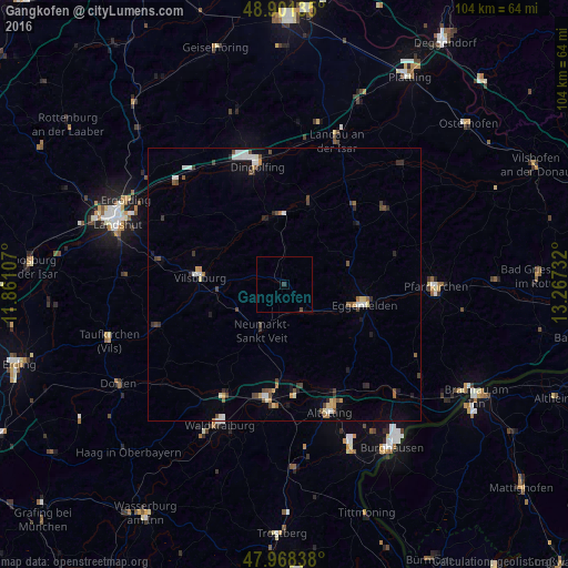
Analysis of Gangkofen night lights 2016
Square area 10x10 km:
 0%
0%90-99
0%80-89
0%70-79
0%60-69
0%50-59
0%40-49
0.57%30-39
0.57%20-29
0%10-19
0%0-9
98.86%Square area 50x50 km:
0.37%90-99
0.43%80-89
0.27%70-79
0.22%60-69
0.24%50-59
0.34%40-49
0.7%30-39
0.4%20-29
0.36%10-19
0.69%0-9
95.99%Clear (daylight) street map image can be seen on geolist.org.
Map coordinates:
48° 54' 4.9" North, 11° 51' 39.9" East
48° 26' 13.2" North, 12° 33' 51.1" East
47° 58' 6.2" North, 13° 16' 2.4" East
Some cities around Gangkofen sort by population:
• Eggenfelden
14.7 km =9.1 mi,  103°
103°
• Vilsbiburg
15.5 km =9.6 mi,  276°
276°
• Töging am Inn
19.7 km =12.2 mi,  175°
175°
• Reisbach
15.5 km =9.6 mi,  17°
17°
• Ruhstorf
14.4 km =8.9 mi,  37°
37°
• Neumarkt-Sankt Veit
9.5 km =5.9 mi,  206°
206°
• Rohrbach
16.4 km =10.2 mi, 182°
• Bodenkirchen
14.6 km =9.1 mi,  245°
245°
2922716 (p: 6,638)
Sources (retrieved 2019-11-25):
» Earth at Night: Flat Maps 2012, 2016