Schöneiche night lights from space
Night Light of Schöneiche (Brandenburg) from space (Germany) Src. Average luminocity for 10x10km area is 29.5025% and for 50x50km: 25.2409%.
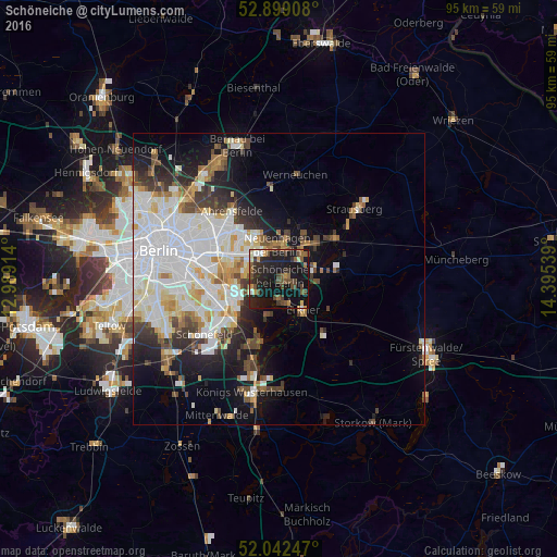
Analysis of Schöneiche night lights 2016
Square area 10x10 km:
 1.39%
1.39%90-99
2.9%80-89
1.77%70-79
4.17%60-69
3.03%50-59
7.07%40-49
8.71%30-39
5.05%20-29
11.87%10-19
41.54%0-9
12.5%Square area 50x50 km:
7.83%90-99
6.35%80-89
2.4%70-79
1.91%60-69
1.84%50-59
2.25%40-49
2.98%30-39
2.78%20-29
3.9%10-19
9.39%0-9
58.37%Clear (daylight) street map image can be seen on geolist.org.
Map coordinates:
52° 53' 56.7" North, 12° 59' 20.9" East
52° 28' 22.3" North, 13° 41' 32.1" East
52° 2' 32.9" North, 14° 23' 43.4" East
Some cities around Schöneiche sort by population:
• Berlin Köpenick
8.2 km =5.1 mi,  245°
245°
• Mahlsdorf
6.7 km =4.2 mi,  307°
307°
• Friedrichshagen
5.2 km =3.2 mi,  241°
241°
• Neuenhagen
6.3 km =3.9 mi,  358°
358°
• Erkner
7.2 km =4.5 mi,  144°
144°
• Rahnsdorf
3.5 km =2.2 mi,  185°
185°
• Woltersdorf
4.4 km =2.7 mi,  116°
116°
• Müggelheim
7.1 km =4.4 mi,  195°
195°
2836746 (p: 11,907)
Sources (retrieved 2019-11-25):
» Earth at Night: Flat Maps 2012, 2016