Münstertal/Schwarzwald night lights from space
Night Light of Münstertal/Schwarzwald (Baden-Württemberg) from space (Germany) Src. Average luminocity for 10x10km area is 1.4886% and for 50x50km: 7.688%.
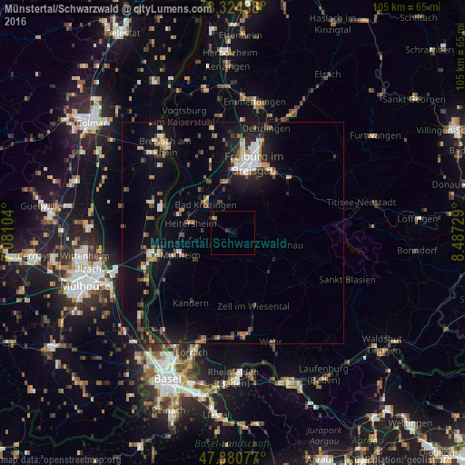
Analysis of Münstertal/Schwarzwald night lights 2016
Square area 10x10 km:
 0%
0%90-99
0%80-89
0%70-79
0.28%60-69
0.85%50-59
0%40-49
0%30-39
0.57%20-29
0.28%10-19
1.14%0-9
96.88%Square area 50x50 km:
0.87%90-99
1.03%80-89
0.48%70-79
1.02%60-69
0.89%50-59
0.98%40-49
1.13%30-39
1.02%20-29
1.91%10-19
6.81%0-9
83.86%Clear (daylight) street map image can be seen on geolist.org.
Map coordinates:
48° 19' 27.8" North, 7° 4' 51.7" East
47° 51' 17" North, 7° 47' 3" East
47° 22' 50.8" North, 8° 29' 14.2" East
Some cities around Münstertal/Schwarzwald sort by population:
• Freiburg
16.5 km =10.3 mi,  17°
17°
• Müllheim
12.6 km =7.8 mi,  245°
245°
• Unterkrozingen
10 km =6.2 mi,  315°
315°
• Neuenburg am Rhein
17.3 km =10.7 mi, 254°
• Zell im Wiesental
17.4 km =10.8 mi,  162°
162°
• Schallstadt
11.7 km =7.3 mi,  350°
350°
• Heitersheim
9.7 km =6 mi,  283°
283°
• Todtnau
12.2 km =7.6 mi,  103°
103°
6559224 (p: 5,199)
Sources (retrieved 2019-11-25):
» Earth at Night: Flat Maps 2012, 2016