Müllheim night lights from space
Night Light of Müllheim (Baden-Württemberg) from space (Germany) Src. Average luminocity for 10x10km area is 7.8289% and for 50x50km: 14.8073%.
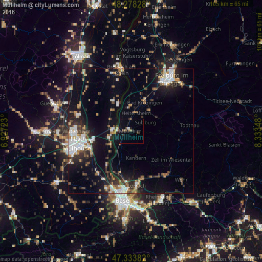
Analysis of Müllheim night lights 2016
Square area 10x10 km:
 0.15%
0.15%90-99
1.04%80-89
0.6%70-79
0%60-69
1.49%50-59
1.34%40-49
1.04%30-39
1.93%20-29
1.64%10-19
3.87%0-9
86.9%Square area 50x50 km:
2.81%90-99
2.38%80-89
1.01%70-79
1.68%60-69
1.43%50-59
1.78%40-49
1.93%30-39
2.36%20-29
3.66%10-19
10.15%0-9
70.8%Clear (daylight) street map image can be seen on geolist.org.
Map coordinates:
48° 16' 41.8" North, 6° 55' 38" East
47° 48' 29.5" North, 7° 37' 49.3" East
47° 20' 1.8" North, 8° 20' 0.5" East
Some cities around Müllheim sort by population:
• Unterkrozingen
13.1 km =8.1 mi,  19°
19°
• Rixheim, FR
18.3 km =11.4 mi,  249°
249°
• Neuenburg am Rhein
5.3 km =3.3 mi,  277°
277°
• Efringen-Kirchen
18.2 km =11.3 mi,  195°
195°
• Kandern
10.8 km =6.7 mi,  167°
167°
• Heitersheim
7.7 km =4.8 mi, 15°
• Schliengen
7 km =4.3 mi,  215°
215°
• Münstertal/Schwarzwald
12.6 km =7.8 mi,  65°
65°
2867770 (p: 18,097)
Sources (retrieved 2019-11-25):
» Earth at Night: Flat Maps 2012, 2016