Mömbris night lights from space
Night Light of Mömbris (Bavaria) from space (Germany) Src. Average luminocity for 10x10km area is 3.3221% and for 50x50km: 9.1091%.
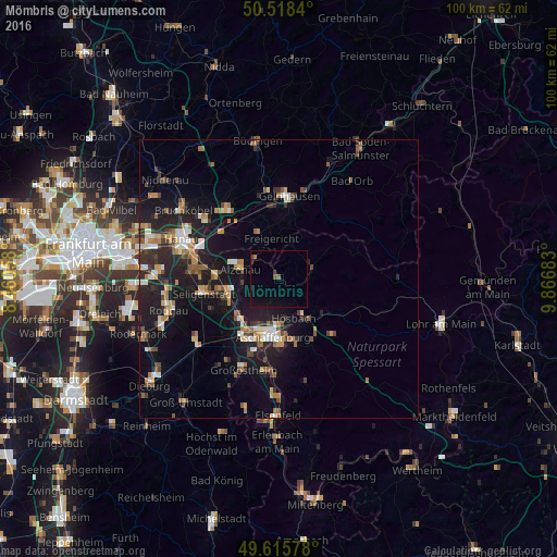
Analysis of Mömbris night lights 2016
Square area 10x10 km:
 0%
0%90-99
0%80-89
0%70-79
0%60-69
0.56%50-59
1.12%40-49
0.56%30-39
0.56%20-29
0.42%10-19
1.96%0-9
94.82%Square area 50x50 km:
0.82%90-99
1.27%80-89
0.8%70-79
0.9%60-69
1.62%50-59
1.29%40-49
1.24%30-39
1.22%20-29
3.07%10-19
8.96%0-9
78.8%Clear (daylight) street map image can be seen on geolist.org.
Map coordinates:
50° 31' 6.2" North, 8° 27' 38.1" East
50° 4' 9.2" North, 9° 9' 49.4" East
49° 36' 56.8" North, 9° 52' 0.6" East
Some cities around Mömbris sort by population:
• Aschaffenburg
10.3 km =6.4 mi,  184°
184°
• Alzenau in Unterfranken
7.4 km =4.6 mi,  287°
287°
• Hösbach
7.7 km =4.8 mi,  155°
155°
• Goldbach
7.9 km =4.9 mi,  169°
169°
• Kleinostheim
10.4 km =6.5 mi,  222°
222°
• Mainaschaff
11.1 km =6.9 mi,  208°
208°
• Kahl am Main
11.3 km =7 mi,  270°
270°
• Laufach
11.4 km =7.1 mi,  120°
120°
2869936 (p: 12,287)
Sources (retrieved 2019-11-25):
» Earth at Night: Flat Maps 2012, 2016