Michendorf night lights from space
Night Light of Michendorf (Brandenburg) from space (Germany) Src. Average luminocity for 10x10km area is 13.6452% and for 50x50km: 15.0704%.
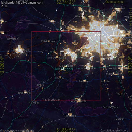
Analysis of Michendorf night lights 2016
Square area 10x10 km:
 1.52%
1.52%90-99
2.27%80-89
0.25%70-79
1.01%60-69
1.89%50-59
1.39%40-49
0.76%30-39
1.77%20-29
3.79%10-19
16.41%0-9
68.94%Square area 50x50 km:
4.45%90-99
3.63%80-89
1.46%70-79
0.95%60-69
1.28%50-59
1.14%40-49
1.33%30-39
1.59%20-29
4.43%10-19
6.39%0-9
73.35%Clear (daylight) street map image can be seen on geolist.org.
Map coordinates:
52° 44' 28.6" North, 12° 19' 36.6" East
52° 18' 48.7" North, 13° 1' 47.9" East
51° 52' 53.7" North, 13° 43' 59.1" East
Some cities around Michendorf sort by population:
• Potsdam
9.8 km =6.1 mi,  14°
14°
• Ludwigsfelde
15.3 km =9.5 mi,  94°
94°
• Werder
9.8 km =6.1 mi,  318°
318°
• Kleinmachnow
16.9 km =10.5 mi,  51°
51°
• Stahnsdorf
14.9 km =9.3 mi,  58°
58°
• Beelitz
9.3 km =5.8 mi,  205°
205°
• Wannsee
14.5 km =9 mi,  35°
35°
• Trebbin
17.1 km =10.6 mi,  129°
129°
2871279 (p: 10,743)
Sources (retrieved 2019-11-25):
» Earth at Night: Flat Maps 2012, 2016