Markt Schwaben night lights from space
Night Light of Markt Schwaben (Bavaria) from space (Germany) Src. Average luminocity for 10x10km area is 5.9911% and for 50x50km: 13.9151%.
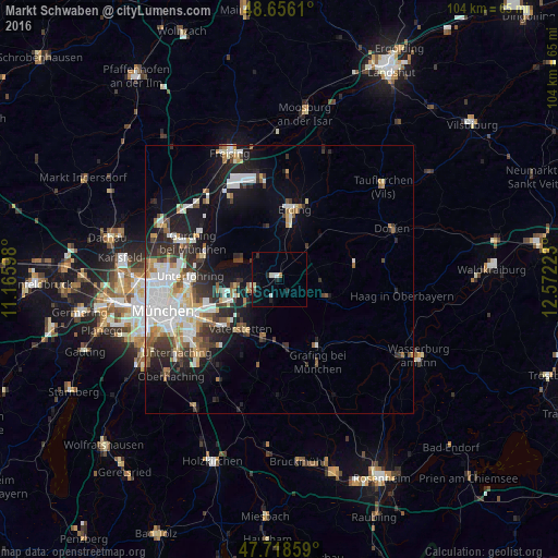
Analysis of Markt Schwaben night lights 2016
Square area 10x10 km:
 0.45%
0.45%90-99
1.93%80-89
0.6%70-79
0%60-69
0.6%50-59
0%40-49
0.6%30-39
0%20-29
2.98%10-19
1.04%0-9
91.82%Square area 50x50 km:
3.22%90-99
2.98%80-89
1.26%70-79
1.26%60-69
1.37%50-59
1.42%40-49
1.45%30-39
2.06%20-29
3.5%10-19
7.53%0-9
73.94%Clear (daylight) street map image can be seen on geolist.org.
Map coordinates:
48° 39' 22" North, 11° 9' 57.5" East
48° 11' 22.2" North, 11° 52' 8.8" East
47° 43' 6.9" North, 12° 34' 20" East
Some cities around Markt Schwaben sort by population:
• Vaterstetten
12 km =7.5 mi,  218°
218°
• Kirchheim bei München
8.5 km =5.3 mi,  260°
260°
• Poing
4.3 km =2.7 mi,  239°
239°
• Kirchseeon
13.2 km =8.2 mi,  173°
173°
• Zorneding
12.2 km =7.6 mi,  195°
195°
• Aschheim
11.5 km =7.1 mi, 259°
• Feldkirchen
11.2 km =7 mi,  245°
245°
• Moosinning
9.9 km =6.2 mi,  349°
349°
2873285 (p: 10,857)
Sources (retrieved 2019-11-25):
» Earth at Night: Flat Maps 2012, 2016