Kirchseeon night lights from space
Night Light of Kirchseeon (Bavaria) from space (Germany) Src. Average luminocity for 10x10km area is 2.1491% and for 50x50km: 11.6925%.
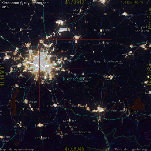
Analysis of Kirchseeon night lights 2016
Square area 10x10 km:
 0%
0%90-99
0%80-89
0%70-79
0%60-69
0.71%50-59
0.43%40-49
0.28%30-39
1.7%20-29
1.56%10-19
0.14%0-9
95.17%Square area 50x50 km:
2.42%90-99
2.52%80-89
1.02%70-79
1.29%60-69
1.25%50-59
1.26%40-49
1.34%30-39
2.11%20-29
2.92%10-19
5.33%0-9
78.54%Clear (daylight) street map image can be seen on geolist.org.
Map coordinates:
48° 32' 20.8" North, 11° 11' 8.3" East
48° 4' 17.1" North, 11° 53' 19.5" East
47° 35' 58" North, 12° 35' 30.8" East
Some cities around Kirchseeon sort by population:
• Vaterstetten
9.7 km =6 mi,  292°
292°
• Haar
12.7 km =7.9 mi, 289°
• Grafing bei München
6.5 km =4 mi,  115°
115°
• Poing
12.1 km =7.5 mi,  334°
334°
• Ebersberg
6.1 km =3.8 mi,  84°
84°
• Zorneding
5 km =3.1 mi, 286°
• Putzbrunn
12.9 km =8 mi,  272°
272°
• Grasbrunn
10.8 km =6.7 mi, 274°
2890381 (p: 9,174)
Sources (retrieved 2019-11-25):
» Earth at Night: Flat Maps 2012, 2016