Aschheim night lights from space
Night Light of Aschheim (Bavaria) from space (Germany) Src. Average luminocity for 10x10km area is 38.5908% and for 50x50km: 18.9526%.
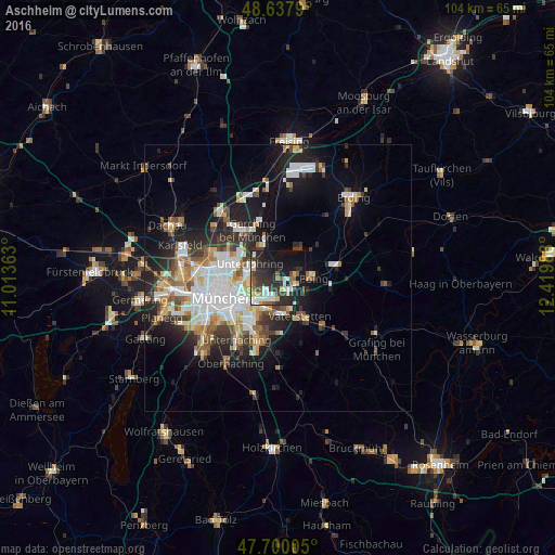
Analysis of Aschheim night lights 2016
Square area 10x10 km:
 5.8%
5.8%90-99
9.08%80-89
2.23%70-79
4.32%60-69
3.57%50-59
4.61%40-49
3.42%30-39
8.33%20-29
21.28%10-19
26.93%0-9
10.42%Square area 50x50 km:
4.06%90-99
4.08%80-89
1.81%70-79
1.81%60-69
2.07%50-59
2.36%40-49
1.99%30-39
2.6%20-29
5.3%10-19
9.84%0-9
64.1%Clear (daylight) street map image can be seen on geolist.org.
Map coordinates:
48° 38' 16.4" North, 11° 0' 49.1" East
48° 10' 16" North, 11° 43' 0.3" East
47° 42' 0.2" North, 12° 25' 11.6" East
Some cities around Aschheim sort by population:
• Bogenhausen
7.8 km =4.8 mi,  254°
254°
• Vaterstetten
8.2 km =5.1 mi,  152°
152°
• Haar
7 km =4.3 mi,  174°
174°
• Ismaning
7.3 km =4.5 mi,  340°
340°
• Kirchheim bei München
2.9 km =1.8 mi,  78°
78°
• Poing
7.6 km =4.7 mi,  90°
90°
• Unterföhring
6 km =3.7 mi,  293°
293°
• Feldkirchen
2.8 km =1.7 mi,  157°
157°
2955159 (p: 6,531)
Sources (retrieved 2019-11-25):
» Earth at Night: Flat Maps 2012, 2016