Kirchheim bei München night lights from space
Night Light of Kirchheim bei München (Bavaria) from space (Germany) Src. Average luminocity for 10x10km area is 26.4494% and for 50x50km: 18.2919%.
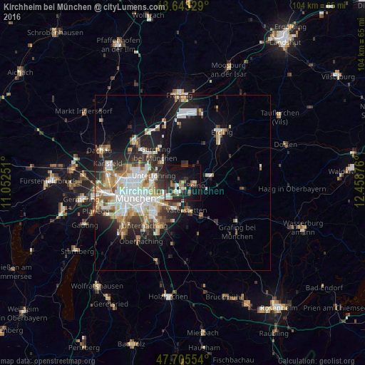
Analysis of Kirchheim bei München night lights 2016
Square area 10x10 km:
 2.23%
2.23%90-99
5.8%80-89
1.49%70-79
2.38%60-69
3.27%50-59
3.42%40-49
3.42%30-39
2.83%20-29
12.2%10-19
30.65%0-9
32.29%Square area 50x50 km:
4.06%90-99
3.99%80-89
1.8%70-79
1.77%60-69
2.03%50-59
2.19%40-49
1.92%30-39
2.41%20-29
4.7%10-19
8.97%0-9
66.17%Clear (daylight) street map image can be seen on geolist.org.
Map coordinates:
48° 38' 35.8" North, 11° 3' 9" East
48° 10' 35.6" North, 11° 45' 20.3" East
47° 42' 19.9" North, 12° 27' 31.5" East
Some cities around Kirchheim bei München sort by population:
• Vaterstetten
8 km =5 mi,  173°
173°
• Haar
7.8 km =4.8 mi,  195°
195°
• Ismaning
8.3 km =5.2 mi,  319°
319°
• Poing
4.7 km =2.9 mi,  98°
98°
• Markt Schwaben
8.5 km =5.3 mi,  80°
80°
• Unterföhring
8.5 km =5.3 mi,  281°
281°
• Aschheim
2.9 km =1.8 mi,  258°
258°
• Feldkirchen
3.7 km =2.3 mi,  210°
210°
2890479 (p: 12,135)
Sources (retrieved 2019-11-25):
» Earth at Night: Flat Maps 2012, 2016