Lübbenau night lights from space
Night Light of Lübbenau (Brandenburg) from space (Germany) Src. Average luminocity for 10x10km area is 4.4747% and for 50x50km: 1.1719%.
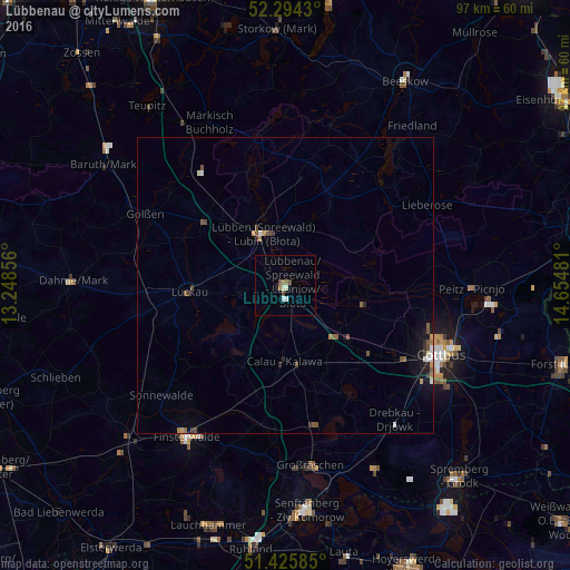
Analysis of Lübbenau night lights 2016
Square area 10x10 km:
 0.51%
0.51%90-99
1.01%80-89
0.51%70-79
0%60-69
0.88%50-59
0.63%40-49
1.52%30-39
0%20-29
0.51%10-19
0%0-9
94.44%Square area 50x50 km:
0.08%90-99
0.18%80-89
0.06%70-79
0.11%60-69
0.17%50-59
0.27%40-49
0.36%30-39
0.13%20-29
0.16%10-19
0.67%0-9
97.8%Clear (daylight) street map image can be seen on geolist.org.
Map coordinates:
52° 17' 39.5" North, 13° 14' 54.8" East
51° 51' 43.8" North, 13° 57' 6" East
51° 25' 33.1" North, 14° 39' 17.3" East
Some cities around Lübbenau sort by population:
• Cottbus
28.4 km =17.6 mi,  114°
114°
• Finsterwalde
30.5 km =19 mi,  213°
213°
• Großräschen
30.8 km =19.1 mi,  172°
172°
• Luckau
16.8 km =10.4 mi,  266°
266°
• Kolkwitz
24 km =14.9 mi,  121°
121°
• Vetschau
12.2 km =7.6 mi,  133°
133°
• Calau
13.1 km =8.1 mi,  179°
179°
• Drebkau
29.7 km =18.5 mi,  141°
141°
2875623 (p: 17,461)
Sources (retrieved 2019-11-25):
» Earth at Night: Flat Maps 2012, 2016