Lingenfeld night lights from space
Night Light of Lingenfeld (Rheinland-Pfalz) from space (Germany) Src. Average luminocity for 10x10km area is 18.381% and for 50x50km: 20.6041%.
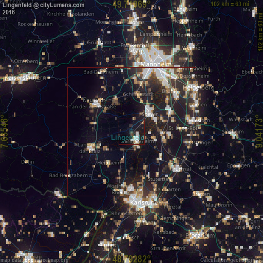
Analysis of Lingenfeld night lights 2016
Square area 10x10 km:
 4.01%
4.01%90-99
3.74%80-89
0.53%70-79
1.2%60-69
0.27%50-59
1.2%40-49
3.07%30-39
1.74%20-29
4.95%10-19
30.88%0-9
48.4%Square area 50x50 km:
3.02%90-99
3.45%80-89
1.92%70-79
1.96%60-69
2.35%50-59
2.23%40-49
2.77%30-39
3.02%20-29
7.47%10-19
19.95%0-9
51.85%Clear (daylight) street map image can be seen on geolist.org.
Map coordinates:
49° 42' 38.5" North, 7° 38' 7.7" East
49° 15' 14" North, 8° 20' 19" East
48° 47' 34.2" North, 9° 2' 30.2" East
Some cities around Lingenfeld sort by population:
• Speyer
10 km =6.2 mi,  42°
42°
• Germersheim
3.9 km =2.4 mi,  151°
151°
• Philippsburg
9.2 km =5.7 mi,  105°
105°
• Oberhausen-Rheinhausen
9.9 km =6.2 mi,  77°
77°
• Bellheim
7.5 km =4.7 mi,  214°
214°
• Rülzheim
11.7 km =7.3 mi,  196°
196°
• Offenbach an der Queich
12.1 km =7.5 mi,  237°
237°
• Dudenhofen
8.1 km =5 mi,  26°
26°
2877082 (p: 5,433)
Sources (retrieved 2019-11-25):
» Earth at Night: Flat Maps 2012, 2016