Philippsburg night lights from space
Night Light of Philippsburg (Baden-Württemberg) from space (Germany) Src. Average luminocity for 10x10km area is 21.1016% and for 50x50km: 22.0045%.
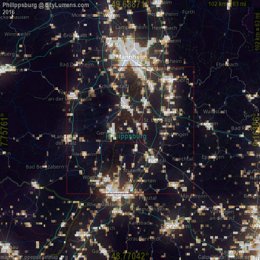
Analysis of Philippsburg night lights 2016
Square area 10x10 km:
 1.87%
1.87%90-99
2.14%80-89
0.53%70-79
1.87%60-69
3.21%50-59
1.6%40-49
4.55%30-39
1.2%20-29
3.34%10-19
54.81%0-9
24.87%Square area 50x50 km:
3.06%90-99
3.63%80-89
2.2%70-79
2%60-69
2.55%50-59
2.43%40-49
2.93%30-39
3.09%20-29
7.81%10-19
22.4%0-9
47.9%Clear (daylight) street map image can be seen on geolist.org.
Map coordinates:
49° 41' 19.4" North, 7° 45' 27.4" East
49° 13' 54.1" North, 8° 27' 38.7" East
48° 46' 13.5" North, 9° 9' 49.9" East
Some cities around Philippsburg sort by population:
• Germersheim
7.1 km =4.4 mi,  262°
262°
• Waghäusel
4.3 km =2.7 mi,  61°
61°
• Graben-Neudorf
7.6 km =4.7 mi,  162°
162°
• Oberhausen-Rheinhausen
4.8 km =3 mi,  9°
9°
• Neulußheim
8.5 km =5.3 mi,  29°
29°
• Lingenfeld
9.2 km =5.7 mi,  285°
285°
• Hambrücken
7.4 km =4.6 mi,  128°
128°
• Altlußheim
8.3 km =5.2 mi,  19°
19°
2853907 (p: 12,359)
Sources (retrieved 2019-11-25):
» Earth at Night: Flat Maps 2012, 2016