Bellheim night lights from space
Night Light of Bellheim (Rheinland-Pfalz) from space (Germany) Src. Average luminocity for 10x10km area is 8.5896% and for 50x50km: 17.305%.
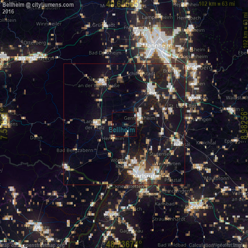
Analysis of Bellheim night lights 2016
Square area 10x10 km:
 0.56%
0.56%90-99
1.4%80-89
0.14%70-79
0.42%60-69
0.98%50-59
0.56%40-49
2.8%30-39
1.12%20-29
0.56%10-19
7%0-9
84.45%Square area 50x50 km:
2.33%90-99
2.71%80-89
1.71%70-79
1.59%60-69
1.92%50-59
1.87%40-49
2.34%30-39
2.55%20-29
5.69%10-19
19%0-9
58.3%Clear (daylight) street map image can be seen on geolist.org.
Map coordinates:
49° 39' 20.3" North, 7° 34' 34.7" East
49° 11' 54" North, 8° 16' 46" East
48° 44' 12.3" North, 8° 58' 57.2" East
Some cities around Bellheim sort by population:
• Landau in der Pfalz
11.8 km =7.3 mi,  270°
270°
• Germersheim
6.7 km =4.2 mi,  65°
65°
• Philippsburg
13.7 km =8.5 mi, 74°
• Linkenheim-Hochstetten
12.2 km =7.6 mi,  127°
127°
• Rülzheim
5.1 km =3.2 mi,  169°
169°
• Jockgrim
11.7 km =7.3 mi,  181°
181°
• Offenbach an der Queich
5.9 km =3.7 mi, 266°
• Lingenfeld
7.5 km =4.7 mi,  34°
34°
2951206 (p: 8,494)
Sources (retrieved 2019-11-25):
» Earth at Night: Flat Maps 2012, 2016