Forst night lights from space
Night Light of Forst (Baden-Württemberg) from space (Germany) Src. Average luminocity for 10x10km area is 25.979% and for 50x50km: 20.052%.
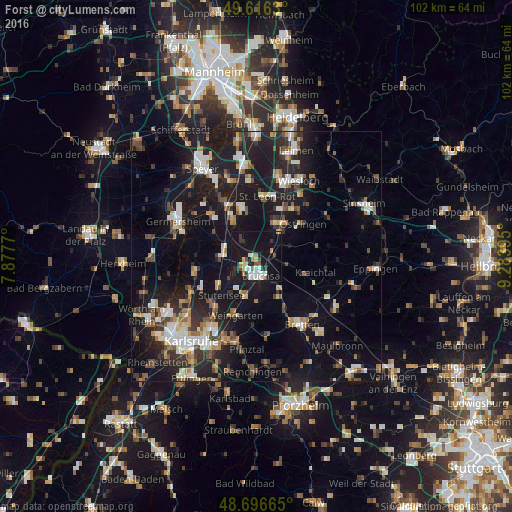
Analysis of Forst night lights 2016
Square area 10x10 km:
 5.04%
5.04%90-99
3.92%80-89
2.8%70-79
1.96%60-69
2.66%50-59
1.82%40-49
2.1%30-39
3.08%20-29
3.92%10-19
43.98%0-9
28.71%Square area 50x50 km:
2.61%90-99
3.13%80-89
1.76%70-79
1.77%60-69
2.37%50-59
2.43%40-49
2.78%30-39
3.01%20-29
6.72%10-19
22.15%0-9
51.28%Clear (daylight) street map image can be seen on geolist.org.
Map coordinates:
49° 36' 58.7" North, 7° 52' 39.7" East
49° 9' 31" North, 8° 34' 51" East
48° 41' 47.9" North, 9° 17' 2.2" East
Some cities around Forst sort by population:
• Bruchsal
4 km =2.5 mi,  161°
161°
• Waghäusel
11.3 km =7 mi,  333°
333°
• Kraichtal
11.1 km =6.9 mi,  97°
97°
• Ubstadt-Weiher
3.7 km =2.3 mi,  82°
82°
• Graben-Neudorf
6.5 km =4 mi,  278°
278°
• Karlsdorf-Neuthard
4.5 km =2.8 mi,  234°
234°
• Kronau
8 km =5 mi,  27°
27°
• Hambrücken
4.6 km =2.9 mi,  320°
320°
2925848 (p: 7,539)
Sources (retrieved 2019-11-25):
» Earth at Night: Flat Maps 2012, 2016