Königsbach-Stein night lights from space
Night Light of Königsbach-Stein (Baden-Württemberg) from space (Germany) Src. Average luminocity for 10x10km area is 10.777% and for 50x50km: 17.2973%.
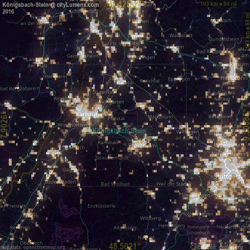
Analysis of Königsbach-Stein night lights 2016
Square area 10x10 km:
 0%
0%90-99
0.14%80-89
0%70-79
0%60-69
0.85%50-59
3.98%40-49
3.55%30-39
2.98%20-29
4.69%10-19
10.94%0-9
72.87%Square area 50x50 km:
1.87%90-99
2.67%80-89
1.57%70-79
1.78%60-69
2.3%50-59
2.16%40-49
2.52%30-39
2.55%20-29
4.47%10-19
17.28%0-9
60.82%Clear (daylight) street map image can be seen on geolist.org.
Map coordinates:
49° 25' 31.2" North, 7° 54' 9.4" East
48° 57' 57.1" North, 8° 36' 20.6" East
48° 30' 7.6" North, 9° 18' 31.9" East
Some cities around Königsbach-Stein sort by population:
• Pforzheim
11.3 km =7 mi,  143°
143°
• Bretten
10.8 km =6.7 mi,  43°
43°
• Birkenfeld
11.2 km =7 mi,  169°
169°
• Weingarten
11.4 km =7.1 mi,  329°
329°
• Knittlingen
12.8 km =8 mi,  59°
59°
• Ispringen
7.1 km =4.4 mi, 140°
• Eutingen an der Enz
12 km =7.5 mi,  119°
119°
• Jöhlingen
7.7 km =4.8 mi,  342°
342°
3206188 (p: 9,906)
Sources (retrieved 2019-11-25):
» Earth at Night: Flat Maps 2012, 2016