Eutingen an der Enz night lights from space
Night Light of Eutingen an der Enz (Baden-Württemberg) from space (Germany) Src. Average luminocity for 10x10km area is 29.7855% and for 50x50km: 15.9409%.
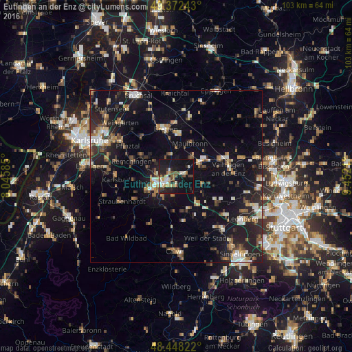
Analysis of Eutingen an der Enz night lights 2016
Square area 10x10 km:
 2.27%
2.27%90-99
6.82%80-89
3.13%70-79
2.13%60-69
4.4%50-59
2.13%40-49
5.54%30-39
2.98%20-29
10.8%10-19
39.06%0-9
20.74%Square area 50x50 km:
1.55%90-99
2.24%80-89
1.4%70-79
1.77%60-69
2.11%50-59
2.21%40-49
2.3%30-39
2.18%20-29
5.64%10-19
15.07%0-9
63.53%Clear (daylight) street map image can be seen on geolist.org.
Map coordinates:
49° 22' 20.7" North, 8° 2' 45.1" East
48° 54' 44.9" North, 8° 44' 56.3" East
48° 26' 53.6" North, 9° 27' 7.6" East
Some cities around Eutingen an der Enz sort by population:
• Pforzheim
4.8 km =3 mi,  229°
229°
• Mühlacker
7.5 km =4.7 mi,  58°
58°
• Niefern-Öschelbronn
2.6 km =1.6 mi,  79°
79°
• Birkenfeld
9.9 km =6.2 mi,  238°
238°
• Maulbronn
10.5 km =6.5 mi,  22°
22°
• Wiernsheim
8.1 km =5 mi,  113°
113°
• Ispringen
6 km =3.7 mi,  274°
274°
• Tiefenbronn
10.6 km =6.6 mi,  158°
158°
2928379 (p: 5,583)
Sources (retrieved 2019-11-25):
» Earth at Night: Flat Maps 2012, 2016