Jöhlingen night lights from space
Night Light of Jöhlingen (Baden-Württemberg) from space (Germany) Src. Average luminocity for 10x10km area is 11.8199% and for 50x50km: 19.2875%.
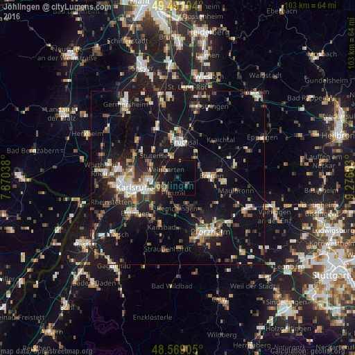
Analysis of Jöhlingen night lights 2016
Square area 10x10 km:
 0%
0%90-99
0%80-89
1.19%70-79
0.74%60-69
2.23%50-59
3.42%40-49
2.53%30-39
1.64%20-29
1.93%10-19
14.88%0-9
71.43%Square area 50x50 km:
2.18%90-99
3%80-89
1.64%70-79
1.95%60-69
2.51%50-59
2.52%40-49
2.86%30-39
2.95%20-29
4.67%10-19
20.6%0-9
55.12%Clear (daylight) street map image can be seen on geolist.org.
Map coordinates:
49° 29' 27.7" North, 7° 52' 13.4" East
49° 1' 55.8" North, 8° 34' 24.6" East
48° 34' 8.6" North, 9° 16' 35.9" East
Some cities around Jöhlingen sort by population:
• Karlsruhe
12.6 km =7.8 mi,  258°
258°
• Bruchsal
10.4 km =6.5 mi,  9°
9°
• Bretten
9.8 km =6.1 mi,  86°
86°
• Königsbach-Stein
7.7 km =4.8 mi,  162°
162°
• Weingarten
4.2 km =2.6 mi,  306°
306°
• Karlsdorf-Neuthard
11.8 km =7.3 mi,  344°
344°
• Forst
14.1 km =8.8 mi,  2°
2°
• Knittlingen
13.3 km =8.3 mi, 93°
2894742 (p: 5,336)
Sources (retrieved 2019-11-25):
» Earth at Night: Flat Maps 2012, 2016