Seligenstadt night lights from space
Night Light of Seligenstadt (Hesse) from space (Germany) Src. Average luminocity for 10x10km area is 22.2689% and for 50x50km: 19.7509%.
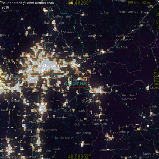
Analysis of Seligenstadt night lights 2016
Square area 10x10 km:
 1.26%
1.26%90-99
0.42%80-89
1.54%70-79
4.9%60-69
2.8%50-59
5.04%40-49
2.1%30-39
3.78%20-29
3.92%10-19
44.68%0-9
29.55%Square area 50x50 km:
3.72%90-99
3.68%80-89
1.72%70-79
1.85%60-69
2.61%50-59
2%40-49
2.32%30-39
3.23%20-29
6.61%10-19
13.47%0-9
58.79%Clear (daylight) street map image can be seen on geolist.org.
Map coordinates:
50° 29' 33.5" North, 8° 16' 15" East
50° 2' 35.5" North, 8° 58' 26.2" East
49° 35' 22.3" North, 9° 40' 37.5" East
Some cities around Seligenstadt sort by population:
• Rodgau
6.6 km =4.1 mi,  253°
253°
• Obertshausen
9.3 km =5.8 mi,  289°
289°
• Alzenau in Unterfranken
8.2 km =5.1 mi,  51°
51°
• Babenhausen
8.8 km =5.5 mi,  190°
190°
• Kleinostheim
8.2 km =5.1 mi,  125°
125°
• Stockstadt am Main
10.7 km =6.6 mi,  139°
139°
• Kahl am Main
3.7 km =2.3 mi,  37°
37°
• Großkrotzenburg
4.5 km =2.8 mi,  8°
8°
2833242 (p: 19,569)
Sources (retrieved 2019-11-25):
» Earth at Night: Flat Maps 2012, 2016