Kitzingen night lights from space
Night Light of Kitzingen (Bavaria) from space (Germany) Src. Average luminocity for 10x10km area is 13.6845% and for 50x50km: 3.4616%.
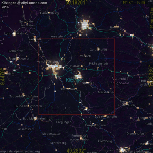

Analysis of Kitzingen night lights 2016
Square area 10x10 km:
 2.01%
2.01%90-99
2.81%80-89
0.4%70-79
1.74%60-69
1.2%50-59
1.6%40-49
1.6%30-39
2.14%20-29
1.6%10-19
7.75%0-9
77.14%Square area 50x50 km:
0.43%90-99
0.54%80-89
0.24%70-79
0.31%60-69
0.43%50-59
0.52%40-49
0.6%30-39
0.56%20-29
0.68%10-19
2.79%0-9
92.91%Clear (daylight) street map image can be seen on geolist.org.
Map coordinates:
50° 11' 31.2" North, 9° 26' 51.4" East
49° 44' 23" North, 10° 9' 2.6" East
49° 16' 59.5" North, 10° 51' 13.9" East
Some cities around Kitzingen sort by population:
• Würzburg
15.5 km =9.6 mi,  292°
292°
• Ochsenfurt
10.5 km =6.5 mi,  217°
217°
• Volkach
14.8 km =9.2 mi,  21°
21°
• Höchberg
19.9 km =12.4 mi,  284°
284°
• Rimpar
19.1 km =11.9 mi,  313°
313°
• Dettelbach
7.1 km =4.4 mi,  8°
8°
• Gerbrunn
12 km =7.5 mi, 289°
• Rottendorf
10.7 km =6.6 mi,  303°
303°
2890158 (p: 21,387)
Sources (retrieved 2019-11-25):
» Earth at Night: Flat Maps 2012, 2016