Ismaning night lights from space
Night Light of Ismaning (Bavaria) from space (Germany) Src. Average luminocity for 10x10km area is 27.1101% and for 50x50km: 19.7386%.
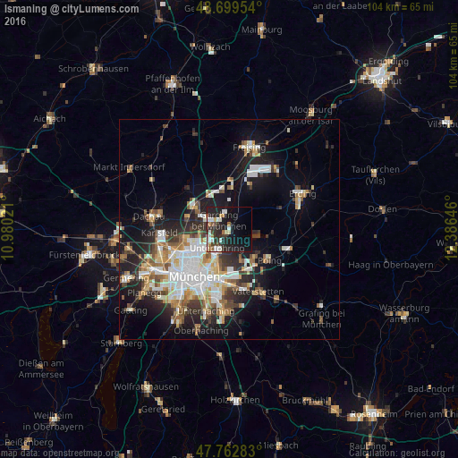
Analysis of Ismaning night lights 2016
Square area 10x10 km:
 3.72%
3.72%90-99
6.7%80-89
1.79%70-79
2.23%60-69
3.13%50-59
0.89%40-49
2.23%30-39
5.36%20-29
13.84%10-19
25.45%0-9
34.67%Square area 50x50 km:
4.12%90-99
4.19%80-89
1.87%70-79
1.91%60-69
2.2%50-59
2.4%40-49
2.18%30-39
2.75%20-29
5.37%10-19
10.84%0-9
62.16%Clear (daylight) street map image can be seen on geolist.org.
Map coordinates:
48° 41' 58.3" North, 10° 58' 48.8" East
48° 13' 60" North, 11° 40' 60" East
47° 45' 46.2" North, 12° 23' 11.3" East
Some cities around Ismaning sort by population:
• Unterschleißheim
9.5 km =5.9 mi,  303°
303°
• Neufahrn bei Freising
9.3 km =5.8 mi,  350°
350°
• Garching bei München
3 km =1.9 mi,  305°
305°
• Eching
8.9 km =5.5 mi,  326°
326°
• Kirchheim bei München
8.3 km =5.2 mi,  139°
139°
• Oberschleißheim
8.8 km =5.5 mi,  282°
282°
• Unterföhring
5.4 km =3.4 mi,  213°
213°
• Aschheim
7.3 km =4.5 mi,  160°
160°
2895643 (p: 14,596)
Sources (retrieved 2019-11-25):
» Earth at Night: Flat Maps 2012, 2016