Ketzin night lights from space
Night Light of Ketzin (Brandenburg) from space (Germany) Src. Average luminocity for 10x10km area is 0.6351% and for 50x50km: 9.6854%.
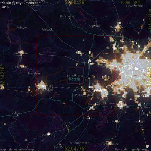
Analysis of Ketzin night lights 2016
Square area 10x10 km:
 0%
0%90-99
0%80-89
0%70-79
0%60-69
0.51%50-59
0%40-49
0.51%30-39
0%20-29
0%10-19
0%0-9
98.99%Square area 50x50 km:
1.34%90-99
1.7%80-89
1.05%70-79
0.87%60-69
1.2%50-59
1.3%40-49
1.2%30-39
0.86%20-29
3.73%10-19
7.92%0-9
78.82%Clear (daylight) street map image can be seen on geolist.org.
Map coordinates:
52° 54' 15.3" North, 12° 8' 31.8" East
52° 28' 41.1" North, 12° 50' 43.1" East
52° 2' 51.9" North, 13° 32' 54.3" East
Some cities around Ketzin sort by population:
• Potsdam
17.3 km =10.7 mi,  120°
120°
• Werder
12.6 km =7.8 mi,  151°
151°
• Nauen
14.5 km =9 mi,  7°
7°
• Kloster Lehnin
18.9 km =11.7 mi,  201°
201°
• Brieselang
15.7 km =9.8 mi,  41°
41°
• Groß Kreutz
9.5 km =5.9 mi,  208°
208°
• Wustermark
10.7 km =6.6 mi, 41°
• Dallgow-Döberitz
16.1 km =10 mi,  63°
63°
2891282 (p: 6,500)
Sources (retrieved 2019-11-25):
» Earth at Night: Flat Maps 2012, 2016