Brieselang night lights from space
Night Light of Brieselang (Brandenburg) from space (Germany) Src. Average luminocity for 10x10km area is 16.2685% and for 50x50km: 18.5226%.
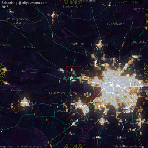
Analysis of Brieselang night lights 2016
Square area 10x10 km:
 2.25%
2.25%90-99
1.46%80-89
0.53%70-79
0.53%60-69
2.65%50-59
5.16%40-49
5.16%30-39
2.12%20-29
1.06%10-19
4.23%0-9
74.87%Square area 50x50 km:
4.8%90-99
4.41%80-89
1.79%70-79
1.39%60-69
1.84%50-59
2.02%40-49
2.12%30-39
2.35%20-29
4.79%10-19
7.23%0-9
67.26%Clear (daylight) street map image can be seen on geolist.org.
Map coordinates:
53° 0' 30.5" North, 12° 17' 48.8" East
52° 34' 60" North, 13° 0' 0" East
52° 9' 14.5" North, 13° 42' 11.3" East
Some cities around Brieselang sort by population:
• Staaken
11.4 km =7.1 mi,  117°
117°
• Wilhelmstadt
13.6 km =8.5 mi, 118°
• Falkensee
6.8 km =4.2 mi,  112°
112°
• Falkenhagener Feld
11.9 km =7.4 mi, 107°
• Spandau
13.9 km =8.6 mi,  104°
104°
• Nauen
8.9 km =5.5 mi,  287°
287°
• Wustermark
5 km =3.1 mi,  222°
222°
• Dallgow-Döberitz
6 km =3.7 mi,  138°
138°
2944126 (p: 10,379)
Sources (retrieved 2019-11-25):
» Earth at Night: Flat Maps 2012, 2016