Dallgow-Döberitz night lights from space
Night Light of Dallgow-Döberitz (Brandenburg) from space (Germany) Src. Average luminocity for 10x10km area is 23.4392% and for 50x50km: 23.8355%.
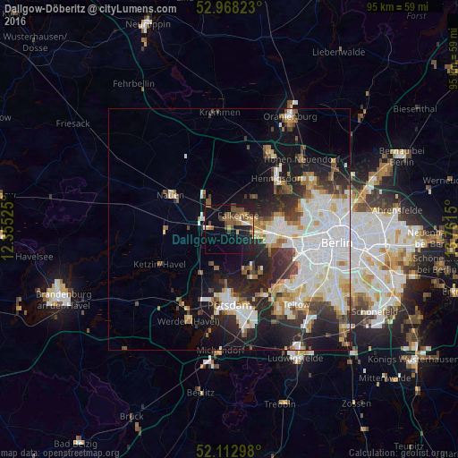
Analysis of Dallgow-Döberitz night lights 2016
Square area 10x10 km:
 0.53%
0.53%90-99
2.12%80-89
2.25%70-79
3.31%60-69
3.57%50-59
7.01%40-49
5.56%30-39
2.78%20-29
4.89%10-19
23.28%0-9
44.71%Square area 50x50 km:
6.7%90-99
5.78%80-89
2.27%70-79
1.72%60-69
2.15%50-59
2.36%40-49
2.49%30-39
2.67%20-29
6.07%10-19
9.85%0-9
57.93%Clear (daylight) street map image can be seen on geolist.org.
Map coordinates:
52° 58' 5.6" North, 12° 21' 18.9" East
52° 32' 33.7" North, 13° 3' 30.1" East
52° 6' 46.7" North, 13° 45' 41.4" East
Some cities around Dallgow-Döberitz sort by population:
• Staaken
6.3 km =3.9 mi,  96°
96°
• Wilhelmstadt
8.3 km =5.2 mi, 104°
• Falkensee
3 km =1.9 mi,  50°
50°
• Falkenhagener Feld
7.5 km =4.7 mi,  82°
82°
• Spandau
9.6 km =6 mi, 84°
• Hakenfelde
10.3 km =6.4 mi, 79°
• Brieselang
6 km =3.7 mi,  318°
318°
• Wustermark
7.4 km =4.6 mi,  276°
276°
6547590 (p: 7,439)
Sources (retrieved 2019-11-25):
» Earth at Night: Flat Maps 2012, 2016