Kloster Lehnin night lights from space
Night Light of Kloster Lehnin (Brandenburg) from space (Germany) Src. Average luminocity for 10x10km area is 0.4949% and for 50x50km: 4.9992%.
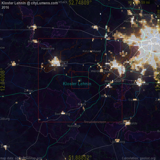
Analysis of Kloster Lehnin night lights 2016
Square area 10x10 km:
 0%
0%90-99
0%80-89
0%70-79
0%60-69
0%50-59
0%40-49
1.01%30-39
0%20-29
0%10-19
0%0-9
98.99%Square area 50x50 km:
0.79%90-99
0.85%80-89
0.5%70-79
0.37%60-69
0.55%50-59
0.62%40-49
0.75%30-39
0.43%20-29
1.19%10-19
4.4%0-9
89.55%Clear (daylight) street map image can be seen on geolist.org.
Map coordinates:
52° 44' 53.1" North, 12° 2' 24.3" East
52° 19' 13.4" North, 12° 44' 35.5" East
51° 53' 18.7" North, 13° 26' 46.8" East
Some cities around Kloster Lehnin sort by population:
• Potsdam
23.6 km =14.7 mi,  68°
68°
• Brandenburg an der Havel
16.9 km =10.5 mi,  309°
309°
• Werder
14.5 km =9 mi,  63°
63°
• Beelitz
18 km =11.2 mi,  120°
120°
• Bad Belzig
22.3 km =13.9 mi,  207°
207°
• Michendorf
19.5 km =12.1 mi,  92°
92°
• Groß Kreutz
9.5 km =5.9 mi,  15°
15°
• Ketzin
18.9 km =11.7 mi, 21°
6691734 (p: 10,669)
Sources (retrieved 2019-11-25):
» Earth at Night: Flat Maps 2012, 2016