Weißensee night lights from space
Night Light of Weißensee (Berlin) from space (Germany) Src. Average luminocity for 10x10km area is 87.2976% and for 50x50km: 35.7004%.
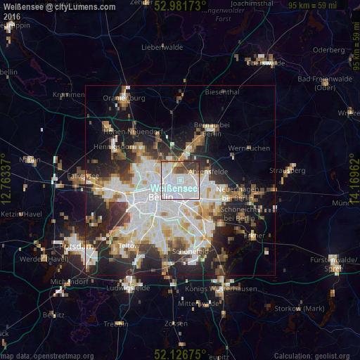

Analysis of Weißensee night lights 2016
Square area 10x10 km:
 48.68%
90-99
24.34%80-89
5.03%70-79
2.38%60-69
3.04%50-59
2.38%40-49
6.75%30-39
6.75%20-29
0.66%10-19
0%0-9
0%Square area 50x50 km:
10.47%90-99
8.98%80-89
3.46%70-79
2.93%60-69
2.99%50-59
3.19%40-49
3.96%30-39
4.37%20-29
7.79%10-19
13.14%0-9
38.72%Clear (daylight) street map image can be seen on geolist.org.
Map coordinates:
52° 58' 54.2" North, 12° 45' 48.1" East
52° 33' 22.8" North, 13° 27' 59.4" East
52° 7' 36.3" North, 14° 10' 10.6" East
Some cities around Weißensee sort by population:
• Prenzlauer Berg
3.4 km =2.1 mi,  235°
235°
• Friedrichshain
4.6 km =2.9 mi,  189°
189°
• Pankow
4.6 km =2.9 mi,  288°
288°
• Neu-Hohenschönhausen
3.3 km =2.1 mi,  69°
69°
• Alt-Hohenschönhausen
2.6 km =1.6 mi,  115°
115°
• Fennpfuhl
3 km =1.9 mi,  172°
172°
• Blankenburg
4.1 km =2.5 mi,  349°
349°
• Heinersdorf
2.6 km =1.6 mi,  311°
311°
2813187 (p: 47,693)
Sources (retrieved 2019-11-25):
» Earth at Night: Flat Maps 2012, 2016