Hilter night lights from space
Night Light of Hilter (Lower Saxony) from space (Germany) Src. Average luminocity for 10x10km area is 5.9458% and for 50x50km: 5.1693%.
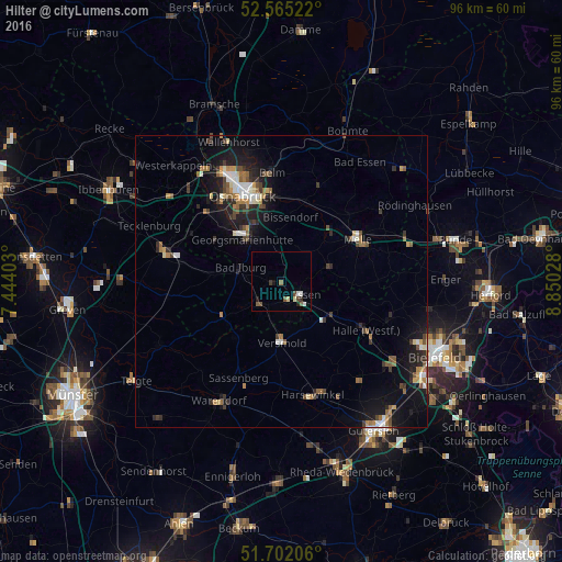
Analysis of Hilter night lights 2016
Square area 10x10 km:
 0.26%
0.26%90-99
1.32%80-89
1.06%70-79
0%60-69
0.79%50-59
1.32%40-49
1.59%30-39
0.53%20-29
1.19%10-19
0.93%0-9
91.01%Square area 50x50 km:
0.48%90-99
0.69%80-89
0.47%70-79
0.47%60-69
0.9%50-59
0.74%40-49
0.85%30-39
0.9%20-29
1.32%10-19
4.42%0-9
88.75%Clear (daylight) street map image can be seen on geolist.org.
Map coordinates:
52° 33' 54.8" North, 7° 26' 38.5" East
52° 8' 8.6" North, 8° 8' 49.7" East
51° 42' 7.4" North, 8° 51' 1" East
Some cities around Hilter sort by population:
• Georgsmarienhütte
10.2 km =6.3 mi,  316°
316°
• Versmold
10.6 km =6.6 mi,  177°
177°
• Bissendorf
10.9 km =6.8 mi,  6°
6°
• Bad Iburg
7.5 km =4.7 mi,  286°
286°
• Dissen
4.2 km =2.6 mi,  121°
121°
• Bad Laer
5.9 km =3.7 mi,  227°
227°
• Borgholzhausen
11.2 km =7 mi,  108°
108°
• Bad Rothenfelde
2.5 km =1.6 mi,  147°
147°
2904607 (p: 10,173)
Sources (retrieved 2019-11-25):
» Earth at Night: Flat Maps 2012, 2016