Bad Iburg night lights from space
Night Light of Bad Iburg (Lower Saxony) from space (Germany) Src. Average luminocity for 10x10km area is 1.1323% and for 50x50km: 4.5791%.
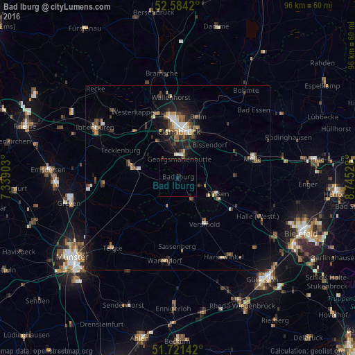
Analysis of Bad Iburg night lights 2016
Square area 10x10 km:
 0%
0%90-99
0%80-89
0%70-79
0%60-69
0%50-59
0%40-49
0%30-39
0%20-29
0.66%10-19
1.06%0-9
98.28%Square area 50x50 km:
0.44%90-99
0.64%80-89
0.38%70-79
0.37%60-69
0.81%50-59
0.7%40-49
0.73%30-39
0.94%20-29
1.05%10-19
3.3%0-9
90.65%Clear (daylight) street map image can be seen on geolist.org.
Map coordinates:
52° 35' 3.1" North, 7° 20' 20.5" East
52° 9' 17.6" North, 8° 2' 31.8" East
51° 43' 17.1" North, 8° 44' 43" East
Some cities around Bad Iburg sort by population:
• Georgsmarienhütte
5.3 km =3.3 mi,  1°
1°
• Hagen
6.2 km =3.9 mi,  317°
317°
• Hasbergen
10.7 km =6.6 mi,  328°
328°
• Hilter
7.5 km =4.7 mi,  106°
106°
• Bad Laer
6.7 km =4.2 mi,  155°
155°
• Lienen
4.1 km =2.5 mi,  262°
262°
• Bad Rothenfelde
9.5 km =5.9 mi,  116°
116°
• Glandorf
8.3 km =5.2 mi,  200°
200°
2953430 (p: 11,554)
Sources (retrieved 2019-11-25):
» Earth at Night: Flat Maps 2012, 2016