Hilpoltstein night lights from space
Night Light of Hilpoltstein (Bavaria) from space (Germany) Src. Average luminocity for 10x10km area is 2.0616% and for 50x50km: 4.8938%.
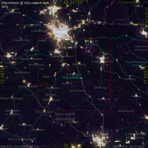
Analysis of Hilpoltstein night lights 2016
Square area 10x10 km:
 0.14%
0.14%90-99
0.42%80-89
0.28%70-79
0.28%60-69
0.56%50-59
0%40-49
0%30-39
0%20-29
0.56%10-19
0.56%0-9
97.2%Square area 50x50 km:
0.59%90-99
0.71%80-89
0.34%70-79
0.48%60-69
0.69%50-59
0.74%40-49
0.78%30-39
1.02%20-29
1.48%10-19
3.22%0-9
89.96%Clear (daylight) street map image can be seen on geolist.org.
Map coordinates:
49° 38' 52.3" North, 10° 29' 14.9" East
49° 11' 25.7" North, 11° 11' 26.2" East
48° 43' 43.7" North, 11° 53' 37.4" East
Some cities around Hilpoltstein sort by population:
• Roth
9.6 km =6 mi,  311°
311°
• Freystadt
10.2 km =6.3 mi,  83°
83°
• Allersberg
7.5 km =4.7 mi,  26°
26°
• Georgensgmünd
12.6 km =7.8 mi,  269°
269°
• Pyrbaum
13.7 km =8.5 mi, 30°
• Thalmässing
11.6 km =7.2 mi,  168°
168°
• Büchenbach
12.9 km =8 mi, 311°
• Heideck
7.8 km =4.8 mi,  216°
216°
2904638 (p: 13,069)
Sources (retrieved 2019-11-25):
» Earth at Night: Flat Maps 2012, 2016