Büchenbach night lights from space
Night Light of Büchenbach (Bavaria) from space (Germany) Src. Average luminocity for 10x10km area is 8.3529% and for 50x50km: 9.444%.
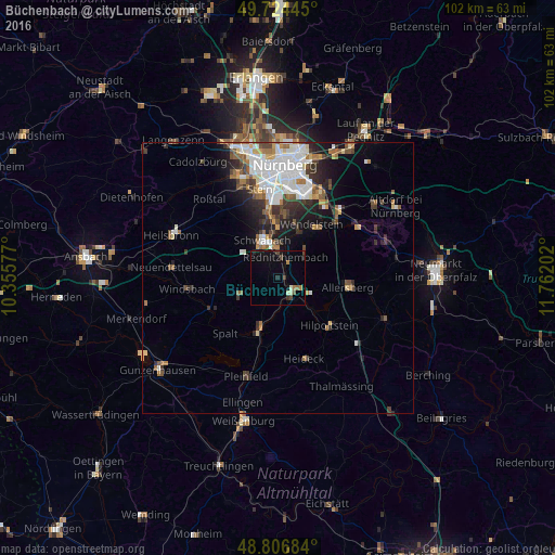
Analysis of Büchenbach night lights 2016
Square area 10x10 km:
 0%
0%90-99
0.94%80-89
0.67%70-79
0.27%60-69
1.74%50-59
0.27%40-49
2.41%30-39
1.74%20-29
1.07%10-19
6.02%0-9
84.89%Square area 50x50 km:
2.37%90-99
1.82%80-89
0.67%70-79
0.71%60-69
1.23%50-59
1.32%40-49
1.19%30-39
1.38%20-29
2.13%10-19
3.63%0-9
83.55%Clear (daylight) street map image can be seen on geolist.org.
Map coordinates:
49° 43' 28" North, 10° 21' 20.8" East
49° 16' 4" North, 11° 3' 32" East
48° 48' 24.6" North, 11° 45' 43.3" East
Some cities around Büchenbach sort by population:
• Schwabach
7.4 km =4.6 mi,  339°
339°
• Roth
3.2 km =2 mi,  133°
133°
• Wendelstein
11.5 km =7.1 mi,  35°
35°
• Hilpoltstein
12.9 km =8 mi, 131°
• Allersberg
13 km =8.1 mi,  98°
98°
• Rednitzhembach
4 km =2.5 mi,  22°
22°
• Georgensgmünd
9.2 km =5.7 mi,  199°
199°
• Abenberg
7.4 km =4.6 mi,  248°
248°
2942612 (p: 5,255)
Sources (retrieved 2019-11-25):
» Earth at Night: Flat Maps 2012, 2016