Hachenburg night lights from space
Night Light of Hachenburg (Rheinland-Pfalz) from space (Germany) Src. Average luminocity for 10x10km area is 1.4104% and for 50x50km: 2.8108%.
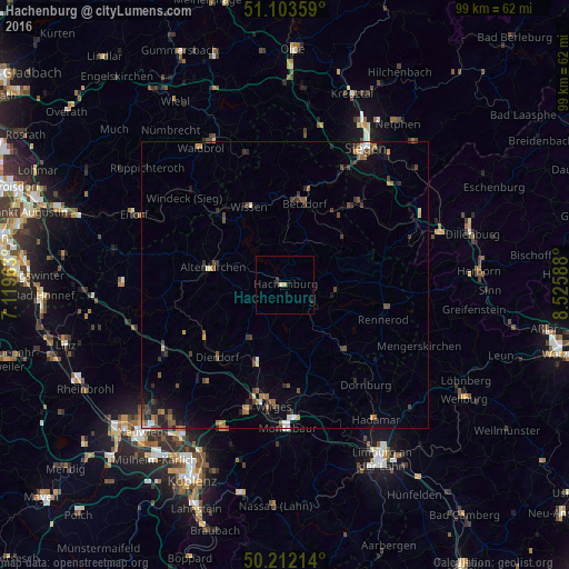
Analysis of Hachenburg night lights 2016
Square area 10x10 km:
 0%
0%90-99
0.27%80-89
0.27%70-79
0.53%60-69
0%50-59
0%40-49
0%30-39
0.4%20-29
0.13%10-19
1.34%0-9
97.06%Square area 50x50 km:
0.21%90-99
0.21%80-89
0.14%70-79
0.32%60-69
0.46%50-59
0.58%40-49
0.66%30-39
0.76%20-29
0.64%10-19
1.45%0-9
94.57%Clear (daylight) street map image can be seen on geolist.org.
Map coordinates:
51° 6' 12.9" North, 7° 7' 10.7" East
50° 39' 35.9" North, 7° 49' 21.9" East
50° 12' 43.7" North, 8° 31' 33.2" East
Some cities around Hachenburg sort by population:
• Betzdorf
15 km =9.3 mi,  13°
13°
• Kirchen
17.1 km =10.6 mi,  15°
15°
• Wissen
14.6 km =9.1 mi,  334°
334°
• Herdorf
15.9 km =9.9 mi,  35°
35°
• Altenkirchen
13.1 km =8.1 mi,  282°
282°
• Dierdorf
17.4 km =10.8 mi,  223°
223°
• Westerburg
15.5 km =9.6 mi,  136°
136°
• Bad Marienberg
9 km =5.6 mi,  97°
97°
2912921 (p: 5,690)
Sources (retrieved 2019-11-25):
» Earth at Night: Flat Maps 2012, 2016